Phase 4 Modeling Schedule
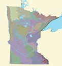
ECS Subsections
Phase 4 models will be developed for Ecological Classification System Subsections. Modeling priority is based on several factors:
- Need to improve the Phase 3 model.
- Availability of sufficient new environmental data to support model improvement.
- Availability of a sufficiently large archaeological database to support model improvement.
Modeling Schedule
| ECS Subsection |
|---|
| Big Woods |
| Minnesota River Prairie |
| The Blufflands |
| Chippewa Plains |
| Rochester Plateau |
St. Paul-Baldwin Plains and Moraines |
| Red River Prairie |
| Oak Savanna |
| Coteau Moraines |
| Inner Coteau |
| Anoka Sand Plain |
| St. Louis Moraines and Tamarack Lowlands |
| Pine Moraines and Outwash Plains |
| Aspen Parklands |
| Agassiz Lowlands and Littlefork-Vermillion Uplands |
| Hardwood Hills |
| North Shore Highlands |
| Mille Lacs Uplands, Glacial Lake Superior Plan, and St. Croix Moraine |
| Laurentian Uplands, Nashwauk Uplands, and Toimi Uplands |
| Border Lakes |