Geotechnical Systems Asset Class
Standardizes the deliverable format for the index (see material matrix below).
- Geotechnical Systems (ERS) Template (Excel)
- Geotechnical Systems (Subgrade Improvement) Template (Excel)
- Geotechnical Systems (Slopes) Template (Excel)
- Geotechnical Systems (Special Drainage) Template (Excel)
- Geotechnical Systems (Instrumentation) Template (Excel)
Geotechnical Systems Feature Collect Index
Geotechnical Systems are point and area features with coordinates recorded as linestring text.
Geotechnical Systems As-built Survey Data Template file
| Geotechnical Systems Class | Geotechnical Feature | Coordinates collect point As Linestring text format: Lat1, Long1, Z1; Lat2, Long2, Z2; Lat3, Long3, Z3 |
Attribute Collect Information |
|---|---|---|---|
Earth Retaining Structures (Wall Systems) |
Bin, Cantilever, Crib, MSE (Mechanically Stabilized Earth), Gravity, Sheet Pile, Soldier Pile, Soil Nail, Other | Collect points to capture asset footprint. Points shall delineate top surface and toe of structure at every major vertex (direction change) or one point every 50’ whichever is more frequent. | 1. Plan ID 2. Material 3. Year Built 4. Comments |
| Slopes | Reinforced Soil Slope, Slope Armoring, Other, | Collect points to capture outer extents of perimeter for each feature at finished ground elevation. Collect points at every major vertex (direction change) or one point ever 50’ (whichever is more frequent). | 1. Plan ID 2. Material 3. Year Built 4. Comments |
| Subgrade (Ground Improvement) | Column-Support Embankment, Geogrid, Lightweight Fill, Load Transfer Platform, Void Filling Repair, Other |
Collect points to capture outer extents of perimeter at the top of elevation for each feature within the subgrade. Collect points at every major vertex (direction change) or one point ever 50’ (whichever is more frequent). | 1. Plan ID 2. Material 3. Year Built 4. Comments |
| Special Drainage | Blanket Drain, Chimney Drain, Geomembrane Cap and Liner, Herringbone Drain, Perforated Drain, Trench Drain, Slope Seepage cutoff, Other (See Comments) | Collect points to capture perimeter of feature and top surface. | 1. Plan ID 2. Year Built 3. Comments |
| Instrumentation system | Cabinet, Gauge, Inclinometer, Piezometer, Pressure Cell, Shape Accel Array (SAA), Other (See Comments) | Center of top of each device if oriented vertically. If not vertically oriented, perimeter of feature. | 1. Plan ID 2. Year Built 3. Comments |
| **Natural Hazards | Areas of known Karst (natural sink holes), Known Seepage Faces (groundwater springs), Mud / Soil Slide, Rock Fall / Slide, Other (See Comments) | N/A | N/A |
**Asset class not to be collected by Construction Contractor
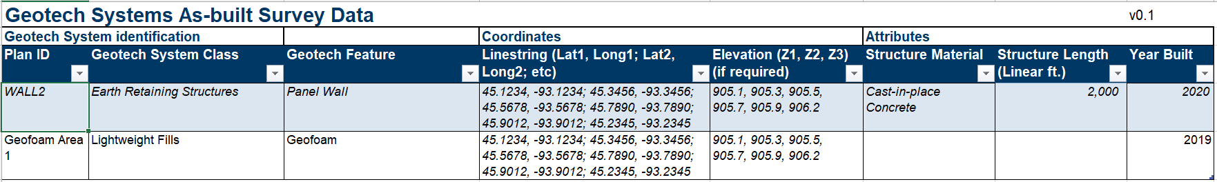
Geotechnical system deliverable example
References
- Material Matrix (PDF) for Deliverable Templates
- Legacy TABLE Z (Excel) format will be accepted until phased out of contracts.