Bicycling in Minnesota | Routes and Maps | U.S. Bicycle Route 45 | Route maps | Digital map files
U.S. Bicycle Route 45 digital map files
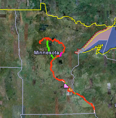
Green lines = Off road segments
Red lines = On road segments
Purple lines = Segments with limited sight lines, shoulder width or surface materials (various) or segments on hard packed gravel (MRT map G between Palisade and Aitkin)
If using Google Earth
- Download and install Google Earth to your computer.
- Download, install and open our USBR 45 Google Earth Map (KMZ). This tool allows you to zoom in to see a rich array of accommodations important to bicyclists, such as restaurants, medical facilities, lodging and camping and more.
If using GPS or mobile device
- If using a mobile device (GPS or phone), download, install and open our USBR 45 GPX file. Note: right click on the link and select "save link as" or "save target as" to download.
NOTE: MnDOT’s GPX file is not downloading properly on some devices; MnDOT is evaluating options. In the meantime, a .gpx map is also available for download from Adventure Cycling: