MnModel Phase 2
Phase 2 models
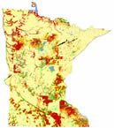
The second phase of MnModel (1997) incorporated additional archaeological and environmental data into the models and extended modeling to the entire state.
Phase 2 Research
In Phase 2, the archaeological database was expanded to include all sites discovered in 'probabilistic surveys.' These included the Minnesota Statewide Archaeological survey and other modern cultural resource surveys. This allowed modeling outside of the 29 MnSAS counties. Experiments were conducted in which specific types of sites were excluded from modeling. Archaeologists suspected that single artifacts could be found almost anywhere and that including them in the database would prevent the model from precisely predicting locations of more important, long-term sites that should have a stronger relationship to the environmental variables.
Additional environmental datasets became available for Phase 2 modeling, as well. New statewide data included historic vegetation and low resolution quaternary geology. Other datasets, including soils, bedrock geology, and digitized maps of historic features, were developed and tested for portions of the state.
Phase 2 Results
The Phase 2 models predicted sites 28%-89% better than by random chance alone. The most successful models excluded single artifacts from the site population. Inclusion of lithic scatters in the database, however, was shown to contribute to model results in most regions.
Lessons Learned from Phase 2
The Phase 2 results made it apparent several problems in the modeling methodology and data. First, the regionalization scheme (Archaeological Resource Regions) was creating artifacts in the models, The region boundaries, often based on modern political boundaries, were often apparent in the contrast between high and low probability areas. Second, the number of sites from 'probabilistic surveys' was too low for modeling in most parts of the state. We needed a larger database. Finally, low resolution data and data that were available for small areas were found not to contribute much information to the models.