Quick Links
- Draft Research Design
- Phase 1 Counties Modeled
- Phase 1 Research
- Phase 1 Model Results
- Phase 2
- Phase 3
- Phase 4
- Glossary
Mn/Model Research Design
Appendix D: Geomorphology/ Geology

Geology is the single most important natural resource variable in any planning or construction job related to the Minnesota Department of Transportation (MnDOT). All other natural and cultural resources are a function of the surrounding geology and geologic processes. For example, the soils, vegetation, and hydrology are all dependent to varying degrees on the underlying geologic strata and how the landscape is shaped. Geomorphology is a geologic discipline that studies both ancient and present-day landscapes and how they evolved. Cultural resources may be part of the geologic strata as in the case of prehistoric and some early historic resources. The past and present cultures that have inhabited the earth built or utilized specific areas based on essential needs such as food, water, shelter, tools, and safety. If our earth's cultures couldn't grow or harvest it on the landscape, they had to "mine" it from the earth! Understanding the geology and geomorphology is therefore critical to understanding cultural resource patterns and trends predicted by any model.
Foth & Van Dyke is solely responsible for the geomorphic and geologic investigations of the Mn/Model program. Geomorphology relies strongly on the ability to describe and interpret soils (i.e., A-E-B-C horizons), stratigraphy, sedimentology, and depositional environments. The geomorphic investigation will act as the "fail-safe" inductive method for predicting cultural resources.
Archival Research
Archival research will include a review of relevant literature, and discussions with local scientists and the mapping staff at the county Soil Conservation Service (SCS) offices of each of the study areas. These discussions may provide information on outcrops that could yield datable materials indicating the absolute or relative ages of the landforms in question and their underlying sediments. Geotechnical borings that the MnDOT may have will also be reviewed at this time. An aerial photographic search will be conducted for the corridor(s) in question to determine if ages or additional landforms may be recognizable. These data and interpretations will be used to further define the areas of geological testing for Subtask B below. The Minnesota Department of Natural Resources surficial mapping projects (both aggregate and ecosystem management) will be consulted if appropriate; however, this mapping project relies strongly upon existing well and boring logs, which typically provide poor details on the younger unconsolidated sediments that contain cultural resources (e.g., radiocarbon ages, soil descriptions, etc.). Typically the "geomorphologists" of Minnesota have not described the surface and buried soils within the Quaternary-aged strata, and little radiocarbon dating has been performed within the valleys. The field work will need to provide a greater detail of documentation and mapping than is currently available, especially for the river valleys.
Field Work
Aerial photography and SCS information provided in the above task will help to locate organic materials for radiocarbon dating. Continuous cores will be collected along upland to lowland transects within or adjacent to the proposed corridors. Borings will allow the chance to test deeper for radiocarbon datable materials. Between the radiocarbon materials and relative dating principles, the landforms and potential cultural components will be bracketed in time.
The field work will include collecting soil samples from beneath each landform for radiocarbon analyses, particle-size analyses, and blowsand analyses, when appropriate. The soils will be described according to United States Department of Agriculture methods; however, these descriptions can be readily transferred into the Unified Soil Classification System for engineering purposes.
The borings will be collected from both state and private properties. Foth & Van Dyke will utilize the MnDOT Foundations Department drilling crews when borings are required along state properties; otherwise, either a or contracted drillers will be used for private properties. Most of the drilling on private property will be accomplished more quickly and cost-effectively with Giddings soil-probes.
Two teams each equipped with a Giddings soil-probe will perform the geologic/geomorphic data collection on the eight study areas. Each soil profile will be described by a geomorphologist or geologist with a post-graduate degree and reviewed for quality control by one of the two senior geomorphologists (C. Hudak or E. Hajic). Boring elevations and locations will be determined by a geographic positioning system (GPS) within a +/- 3 foot margin of error. Each geologic field study area will not be more than 47 square miles per universe studied, or 370 square miles for the entire Mn/Model project spanning Minnesota.
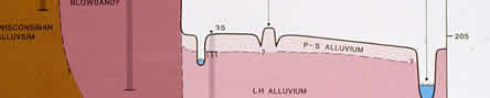
Geomorphic mapping will concentrate on the fluvial systems of Minnesota. Detailed geomorphic mapping projects will be conducted on eight areas within Minnesota that are dissected by fluvial systems. These areas have been studied the least within Minnesota, therefore the ages and preservation potential are not understood. Three-dimensional reconstructions of the valleys will be critical to the predictive modeling of cultural resources.
Radiocarbon-dating the geological strata of Minnesota is extremely important for the success of Mn/Model. Traditional workers in Minnesota geology have ignored the river valleys as sources for radiocarbon materials. Recent unpublished reports and ongoing work by both C. Hudak and E. Hajic of Foth & Van Dyke indicate that ample datable materials exist in most Minnesota valleys. To help decipher the age of both present-day and buried landscapes Foth & Van Dyke will attempt to secure 100 radiocarbon dates from the combined study areas.
A quality control measure will be established for the radiocarbon dates (or lack of) in the headwater valleys of the drainage systems we are investigating. This quality control will interpret paleoenvironments through the relatively quick analysis of plant macrofossils (e.g., fossil seeds, leaves, etc.). Recent work in Iowa valleys indicates that Holocene strata can be age-dated by the biostratigraphic interpretations of plant macrofossils (Richard Baker, personal communication, 1994). As an added benefit to the archaeologists, the valley and upland Holocene paleoenvironments will be interpreted on a closer scale and with more assurance than through the pollen analyses that have been traditionally performed in Minnesota (i.e., pollen travels longer distances than seeds before being deposited and preserved, therefore the seeds will indicate a local paleoenvironmental "story" for both the valleys and uplands). The relatively large numbers of radiocarbon dates will in itself be a quality control.
Data Analyses and interpretation
To better understand the three-dimensions of a particular landform, the geology needs to be described in a standard nationally recognized format. The Mn/Model team will utilize the USDA methods, which can be readily transferred into the Unified Soil Classification System (USCS). Soil samples collected from the field will be examined for particle-sizes and frosted quartz grains to help determine if the landform has been created, buried, disturbed, or destroyed by eolian, fluvial, soil-forming, freeze-thaw, or plant/animal processes. Selected organic materials will be radiocarbon-dated to help determine the absolute ages of the strata or landform surfaces. Profile descriptions, radiocarbon dates, and particle-size data will be assimilated into multiple working hypotheses that the archaeologists may use to carry out their testing tasks.
The geologic and geomorphic data will be digitized by BRW for incorporation into the Geographic Information System (GIS). These digitized data will also be presented to: the Minnesota Department of Natural Resources Minerals Division for their statewide Aggregate Mapping Program, which will then be disseminated to their clients (local government units) for land-use planning; and the Minnesota Department of Natural Resources Forestry Division for incorporation into a statewide geomorphology mapping project related to Ecosystem Management. The later project has concentrated mostly on upland details and incorporates little subsurface, three-dimensional data that could be useful to the predictive modeling. The geomorphologists will also help to verify or modify the SCS data provided by the county mapping programs before finalizing in the GIS. The SCS maps were designed for uses other than cultural resource management; therefore, the SCS maps are not always accurate for our purposes. Typically changes need to be made to the SCS mapping projects to help with predictive modeling.
A text of the geologic and geomorphic interpretations will be provided as part of the final product. This text with figures will be of use to both the Mn/Model program and multiple other federal, state, and local government units. For example, the federal government is currently supporting Ecosystem Management, which relies strongly upon the mapping of the surficial geology and hydrology. Local government units will also be able to more accurately plan for land uses that may not necessarily involve cultural resources, and yet need more subsurface information than the SCS maps may provide. Foth & Van Dyke will share all information with the MnDOT Foundations Department in order to double-up our efforts in areas they propose to perform work. Selected local government units will also be made aware of our research. The project reports will also be supplied to the Minnesota DNR Surface Mapping projects for both Aggregates and Ecosystem Management.
The final report will include "fail-safe" inductive models for the eight study areas that are based on the geological data collected by Foth & Van Dyke staff. These inductive models will assign high, medium, and low potentials for geologically-buried cultural resources (this data will also be included in the statistical GIS model). The model will weigh the likelihood of the strata to contain cultural resources because of both the age and depositional environment, and also the likelihood the cultural resources will be preserved in situ. Both the inductive models and the statistical models are based upon reproducible data documented by the extensive field sampling during and prior to the Mn/Model program.
Geology Time Table
Foth & Van Dyke will complete the geomorphic/geologic field work for the first four selected study areas according to the team schedule. Field and laboratory data will be assimilated in the winter months. As each of the four geomorphic projects is interpreted, the data will be delivered to the GIS specialists to become part of the model for that study area. Geology will also be necessary to set up the models for testing during the second year and for Cultural Resource Management projects in the third year. The field work for testing Mn/Model will be accomplished in the summer and fall months. The test data will be interpreted and provided to the BRW modelers in a timely fashion. A draft report on the geology, geomorphology, and paleoenvironments for all areas studied will submitted to the MnDOT. The draft report will include a "fail-safe" inductive model for the location of geologically-buried cultural resources. A final report will be delivered upon receipt of comments from MnDOT representatives and peer reviewers.

Acknowledgements
MnModel was financed with Transportation Enhancement and State Planning and Research funds from the Federal Highway Administration and a Minnesota Department of Transportation match.
Copyright Notice
The MnModel process and the predictive models it produced are copyrighted by the Minnesota Department of Transportation (MnDOT), 2000. They may not be used without MnDOT's consent.