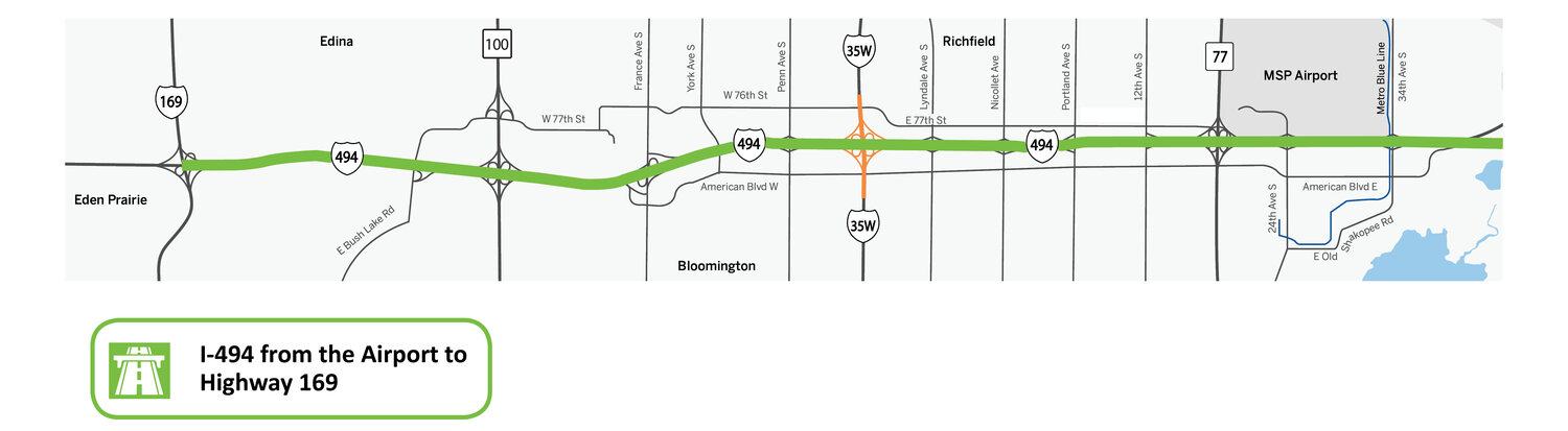
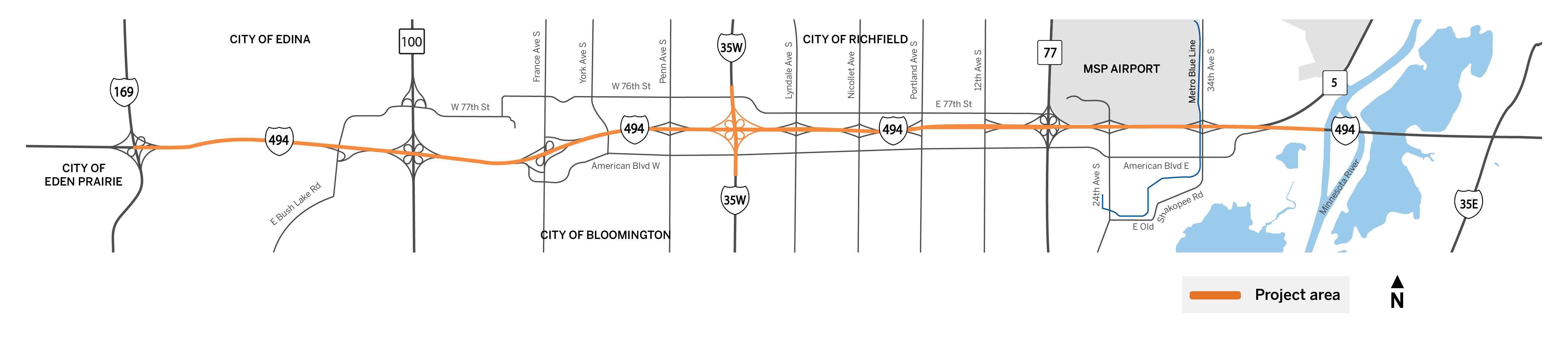
Bloomington, Richfield, Edina, Eden Prairie in Hennepin County
Background
I-494 is a heavily used interstate highway that joins with I-694 to create a loop around the Twin Cities Metro Area. The southwest stretch of the corridor provides direct access to major destinations such as the Minneapolis-St. Paul International Airport and the Mall of America, cross city access for commuters and freight, and local access for the numerous businesses and residents along the freeway. It is also one of the most heavily congested roads in the state.
To address congestion along the southwest portion of I-494, the State of Minnesota has been working with the cities along the corridor, the I-494 Corridor Coalition and the I-35W Solutions Alliance to develop a vision for how the freeway can increase capacity and better serve the growing multimodal needs of the community.
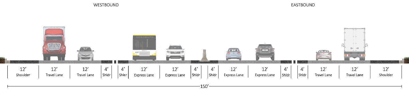
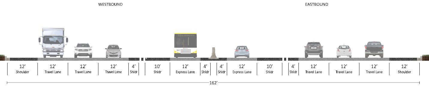
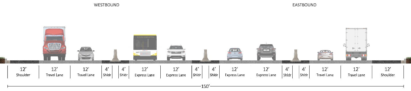
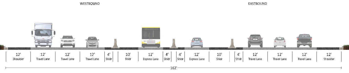
The I-494/Hwy 62 Congestion Relief Study, which concluded in 2017, identified E-ZPASS lanes as key elements in improving the flow of traffic along the freeway. In May of 2018, Corridors of Commerce awarded $134 million in state funds to implement E-ZPASS lanes from EB France Ave. to Hwy 77 and from WB Hwy 77 to I-35W. E-ZPASS provides dedicated lanes to transit, motorcycles, vehicles with two or more occupants, and paid E-ZPASS tag holders to move the most people along the highway. An additional $70 million was awarded to construct a directional ramp for NB I-35W to WB I-494 traffic. In 2021, the United States Department of Transportation (USDOT) awarded $60 million.
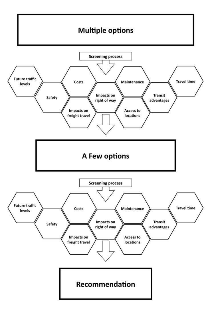
The vision planning process started by talking with local residents, businesses, highway users, cities, counties, agencies, and community groups to find out what goals should guide the design of the interstate. The team then turned these goals and priorities into a set of criteria that helped evaluate different design options. Designs that did not meet the goals set by project partners were eliminated from consideration.
Design options were evaluated based on the following criteria:
How well it accommodates future traffic volumes
How well it improves safety for all users
How well it reduces congestion
How much it costs to build
How much it costs to maintain
How it will impact freight that uses the highway
How it impacts property near the project
Whether it provides an advantage to transit
How it impacts people and communities adjacent to the project
How public input shaped the I-494 Vision
Public input is one of the criteria considered in the design process of the I-494 vision. Public input allowed the design team to better understand community needs and identify key issues that should be addressed.
Since the fall of 2018, we talked with thousands of local and regional residents, businesses, and corridor users to guide the development of future improvements for the I-494 vision.
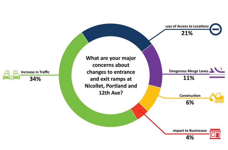
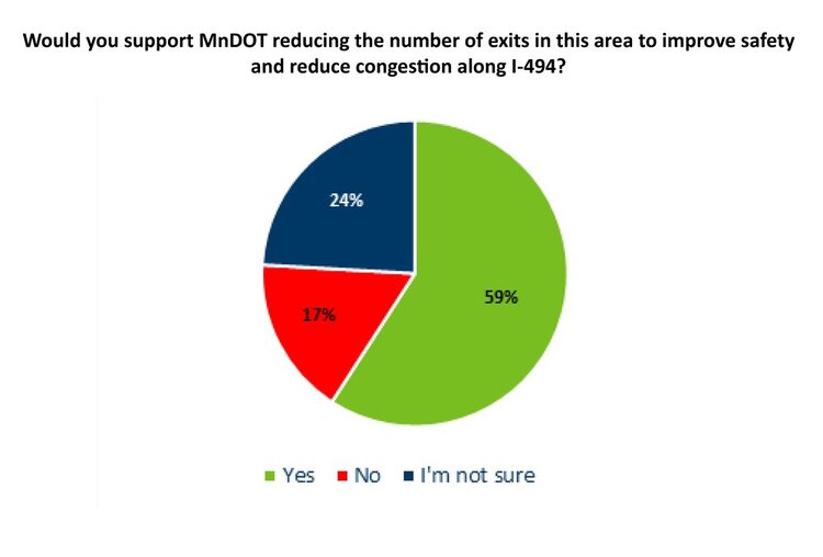
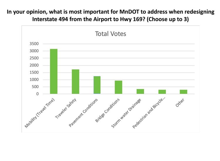
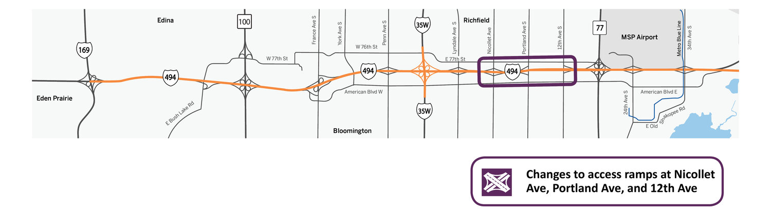
We heard what issues were important to you and got your feedback on changes to access along the highway. You let us know that traffic congestion and safety along the interstate were your main priorities. We heard that drivers felt unsafe by the proximity of entrance and exit ramps near Nicollet Ave., Portland Ave., and 12th Ave. You also let us know that you could support changes to access ramps if they improved these issues.
These conversations were critical in identifying goals that guided the design process.
What is not included for the I-494 mainline?
The project team initially identified eight potential design alternatives. After evaluating design options for the I-494 mainline, the project team eliminated the following options because they did not pass the screening process:
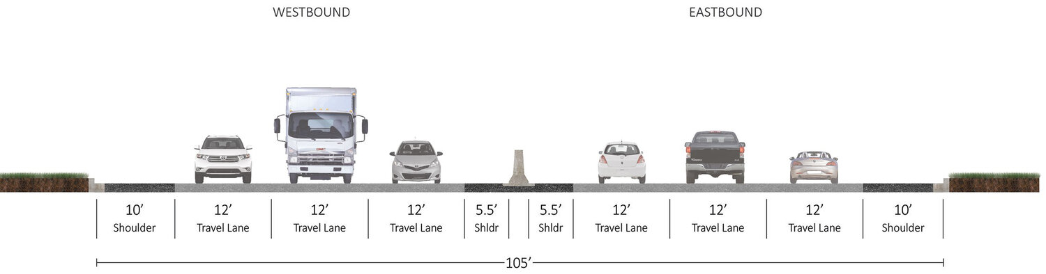
No change to lanes
Every highway project explores a “No Build” option to make sure that the proposed options make improvements on the existing conditions. The “No Build” option would not add any additional lanes to the interstate. This option was eliminated for the following reasons:
Traffic: current and future transportation demands require additional infrastructure to better manage traffic operations
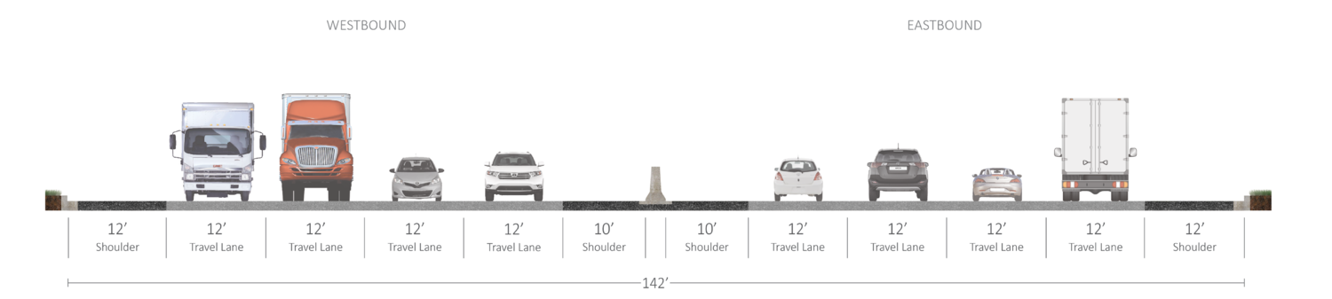
General purpose lanes
This option would add one General Purpose Lane in each direction. This option was eliminated for the following reasons:
Inconsistent with regional plans: regional plans encourage the development of E-ZPass lanes throughout the Twin Cities Metro area
Traffic: provided less improvements to traffic operations in comparison to other designs
Transit: provided minimal benefits for transit users
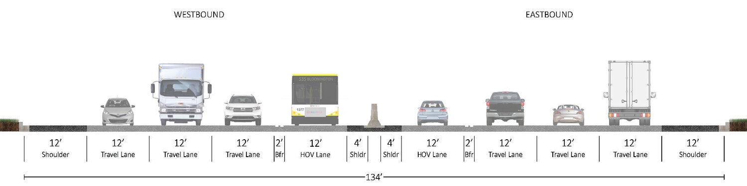
High occupancy vehicle (HOV) lanes
This option would add one high occupancy vehicle (HOV) lane in each direction. This option was eliminated for the following reasons:
Lane usage: additional lane will not be fully used
Buffer separated lanes
This option would convert I-494 to have buffer separated lanes. Two different design options with buffer separated lanes were considered. Both options were eliminated for the following reasons:
Lane usage: additional lane will not be fully used
Traffic: minimal improvements to traffic operations
Costs: high construction and maintenance costs with minimal improvements to traffic operations
Storm water mitigation: will require additional runoff capture structures
Right of way: may require additional land acquisition
Wetlands: May pose greater risks to wetlands
Buffer separated lanes - option one
Two buffer separated lanes are separated from two general purpose lanes. Vehicles on the buffer separated lanes do not have access to entrance and exit ramps.
Buffer separated lanes - option two
One buffered lane is separated from three general purpose lanes. Vehicles on the buffer separated lane do not have access to entrance and exit ramps.
Barrier separated lanes
This option would convert I-494 to have barrier separated lanes. Two different design options with buffer separated lanes were considered. Both options were eliminated for the following reasons:
Lane usage: additional lane will not be fully used
Traffic: minimal improvements to traffic operations
Costs: high construction and maintenance costs with minimal improvements to traffic operations
Storm water mitigation: will require additional runoff capture structures
Right of way: may require additional land acquisition
Wetlands: may pose greater risks to wetlands
Barrier separated lanes - option one
Two barrier separated lanes are separated from two general purpose lanes. Vehicles on the barrier separated lanes do not have access to entrance and exit ramps.
Barrier separated lanes - option two
One barrier separated lane is separated from three general purpose lanes. Vehicles on the barrier separated lanes do not have access to entrance and exit ramps.
What was not included for the Portland Ave. interchange?
The team initially identified five potential interchange alternatives. Initial design options included a Texas U-Turn, Tight Diamond Interchange, Single Point Urban Interchange (SPUI), Roundabout Interchange, and Diverging Diamond Interchange. After evaluating interchange alternatives for Portland Avenue, the following options were eliminated because they did not pass the screening process:
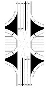
Single point urban interchange (SPUI)
This option would allow opposing left turns to proceed simultaneously by compressing the two intersections of a diamond into one single intersection. This option was eliminated for the following reasons:
Pedestrian and bicycle mobility: Is not best suited to accommodate pedestrian and bicycle movements
Costs: most expensive design option due to longer and wider bridge requirements
Access: may be difficult to access local destinations in the area
Texas u-turn
This option would allow cars traveling on one side of a one-way frontage road to U-turn onto the opposite frontage road. This option was eliminated for the following reasons:
Costs: high construction costs due to additional bridge and lane requirements
Traffic: would require frontage roads to become one-way direction
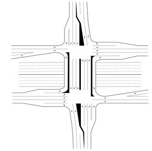
Diverging diamond interchange
This option would accommodate left-turning movements onto arterial roads and highways while eliminating the need for a left-turn signal phase at signalized ramp terminal intersections. This option was eliminated for the following reasons:
Traffic: minimal improvements to traffic operations, does not support local traffic patterns
Transit: least amount of travel time saved for transit routes
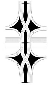
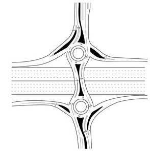
Roundabout interchange
This option would use a series of roundabouts to distribute traffic to connecting roadways and the highway. This option was eliminated for the following reasons:
Traffic: minimal improvements to traffic operations, does not support local traffic patterns
Design: local network does not accommodate enough spacing for design