2025-2027 construction information
Develop project: complete
MnDOT finalized the four-lane highway design of Hwy 10, completed the environmental process and delivered 2025–2027 construction plans in spring 2025. Construction of this project is underway.
- Expand Hwy 10 to four lanes between 620th Ave. and Oink Joint Rd./140th St., includes adjacent roads and entrances. Preferred layout 2023 (PDF)
- Rural:
- 620th Ave. near Bluffton to Co. Rd. 92/11th St. NW in Wadena
- Shady Lane Dr. in Wadena to east of Oink Joint Rd./140th St.
- Urban:
- Co. Rd. 92 to Shady Lane Dr. in Wadena
- Rural:
- Improve accesses and install:
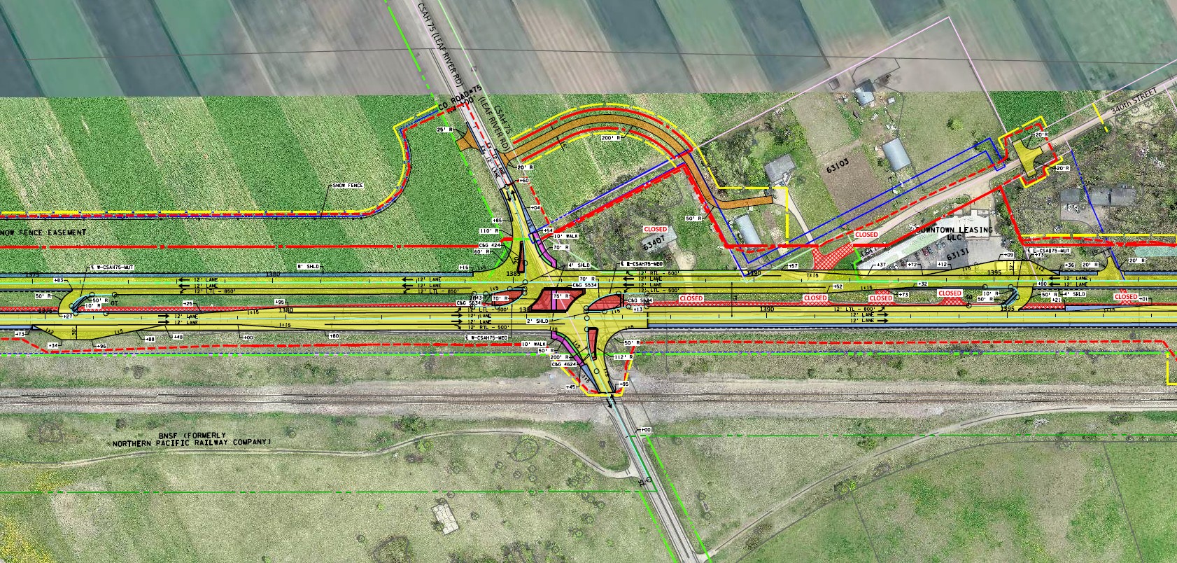
- J-turn at Co. Rd. 75 (JPG)
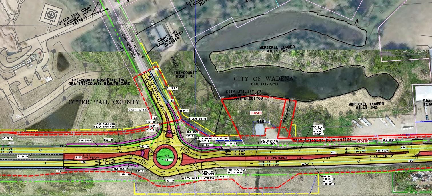
- Roundabout by hospital at Co. Rd. 92/11th St. NW (JPG)
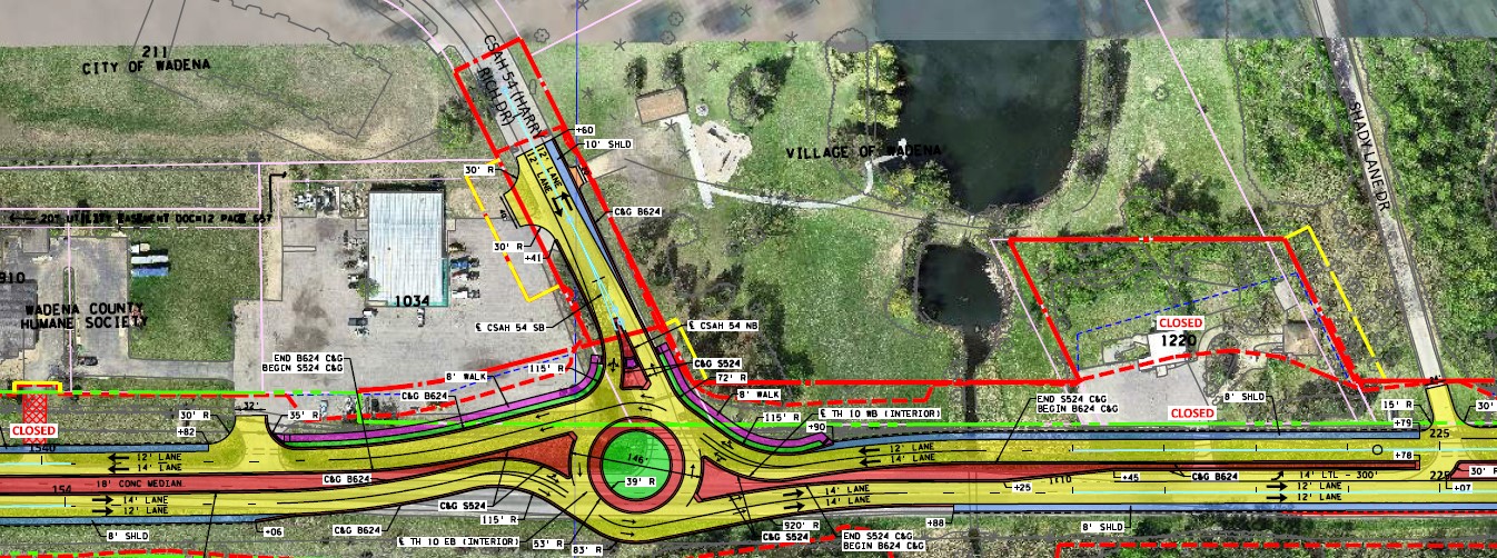
- Roundabout at Harry Rich Dr. (JPG)
- Install drainage structures
- Includes:
- Union Creek between Co. Rd. 4 and Harry Rich Dr.
- Whiskey Creek between Harry Rich Dr. and Shady Ln. Dr.
- Includes:
- Improve pedestrian access
- Extend, add or repair sidewalk in Wadena, includes:
- Extend sidewalk along westbound Hwy 10 county fairgrounds between 9th and 3rd. St. NW in Wadena
- Add pedestrian crossing at Co. Rd. 75
- Install sidewalks to new roundabouts at 640th Ave. and Harry Rich Dr.
- Extend, add or repair sidewalk in Wadena, includes:
- Preferred layout - August 2023 (PDF)
- Photos of accesses:
- J-turn at Co. Rd. 75 (JPG)
- Roundabout by hospital at Co. Rd. 92/11th St NW (JPG)
- Roundabout at Harry Rich Dr. (JPG)
- Findings of Fact and Conclusion (PDF) - Document, attachments
- Environmental Worksheet Assessment (PDF) - Document, attachments
- Safe speed transitions and access management along the corridor
- Anticipate need of federal funding; gap with state bond funds alone
- 2025-2026 roadwork on Hwy 71 and Hwy 29 in Wadena
- Contaminated properties
- BNSF Railway line runs along Hwy 10
- Environmental commitments
- Hospital development in 2022–2023
- Public expectations to construct as soon as possible
- Open house on tentative work and traffic plans during 2025-2027 construction held Feb. 25, 2025 at Maslowski Wellness and Research Center, Wadena
- Environmental Assessment Worksheet open comment period Feb. 13– March 14, 2024.
- Public hearing Oct. 23, 2023 at Wadena City Hall
- Public meeting held Dec. 8, 2022 at Maslowski Wellness & Research Center in Wadena
- Online feedback survey held Aug. 10-Sept. 30, 2022

Crews will:
MnDOT visualizations are computer-generated renderings of proposed road designs, photo simulations and animations. They aid in project development and provide a valuable communication tool for the public.
Eastbound
Watch the Hwy 10 Wadena—eastbound visual flyover (YouTube)
Westbound
Watch the Hwy 10 Wadena—westbound flyover (YouTube)
Published October 2023. Both videos are a work in progress and do not represent all final design details but a three-dimensional drive through once constructed.
In response to the community's input, the project team developed a preferred alternative layout, which includes roundabouts at Co. Rd. 92/11th St. NW (by hospital) and Harry Rich Dr. The final concept further improves access to Hwy 10 and addresses safety concerns as travelers enter the city from the west or east at high speeds.
Finding of Fact and Conclusions
Based upon the information in the record, which comprises the Environmental Assessment Worksheet (EAW) for the proposed project, related studies referenced in the EAW, written comments received, responses to the comments, and other supporting documents included in this Findings of Fact and Conclusions document.
MnDOT makes the following Findings of Fact and Conclusions that the Hwy 10 improvement project will not cause significant environmental impacts. An Environmental Impact Statement is not warranted.
Announcement will be published by the Environmental Quality Board in the EQB Monitor May 14, 2024.
This completes the State environmental review process for the Hwy 10 Wadena project
Environmental Worksheet Assessment
The Environmental Assessment Worksheet (EAW) for proposed improvements to Hwy 10 in Wadena, was available for review and comment Feb. 13 – March 14, 2024. The EAW documents the purpose and need of the project along with the potential environmental impacts.
Section 4(f) Sunnybrook Park impacts
The project will result in a temporary easement of 0.025 acres and permanent acquisition of 0.45 acres from the southern edge of the park. This would reduce the park's size from 80 acres to 79.6 acres. However, a 1.07-acre adjacent parcel will be incorporated into the park as mitigation for impacts under Section 6(f) of the Land and Water Conservation Act. The new size of Sunnybrook Park would be 80.62 acres, a net increase of 0.62 acres over the existing 80-acre park.
The Federal Highway Administration (FHWA) has made a preliminary determination that the proposed action at Sunnybrook Park is a Section 4(f) de minimis action in accordance with 23 CFR 774.5, conditioned on public review and comment. A de minimis finding may be made when uses of Section 4(f) land will have no adverse effect on the protected resources. Open comment period ended Nov. 9, 2023. MnDOT did not receive any comments or concerns.
The Hwy 10 project included an in-depth environmental review process where many issues are looked at, including noise or noise barriers.The 2023 noise analysis concluded that the corridor does not warrant any noise barrier construction along Hwy 10.
Hwy 10 from Moorhead to Hastings is comprised of mostly four-lane expressway with isolated segments of controlled freeway. There is a six-mile gap through Wadena that remains a two-lane highway. The urban segment in Wadena was recently reconstructed in 2020 with a width sufficient for the reconfiguration of the additional through lanes in anticipation of the four-lane expansion of the rural two-lane segments. The rural two‐lane sections east and west of town are in an area of mixed uses, both commercial and agricultural.
In April 2021, District 3 received $5 million of Project Development Bond Funds for the Hwy 10 gap project from the bonding package passed in fall 2020. An additional $30 million of Trunk Highway Bond Funds was appropriated for the project in June 2021 as part of the 2021 Omnibus Transportation Bill.
MnDOT will complete an environmental study, seek public participation and draft preliminary layouts in 2022–2023.
Considerations
Held 2022-2025
Note: This page is no longer updated as of 5/21/2025. Visit Wadena construction for current details.