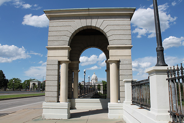
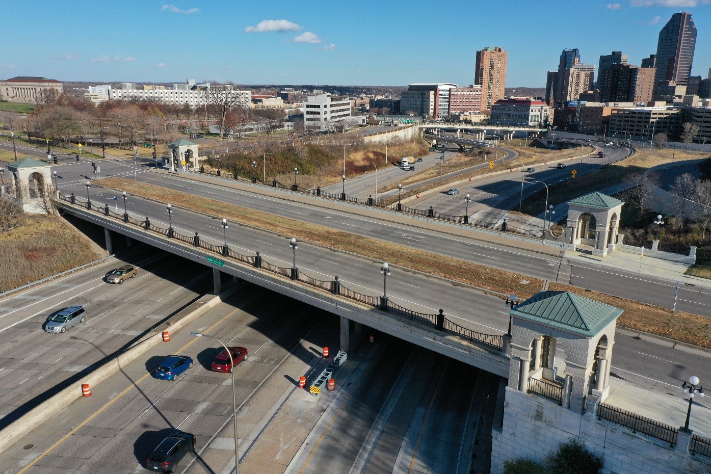
John Ireland Boulevard bridge and nine bridges over I-94 and I-35E
St. Paul
Community engagement report
August 2023
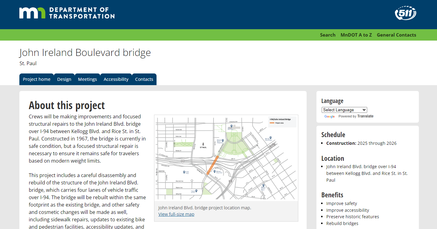
The John Ireland Blvd. bridge is due for structural repairs to ensure it remains safe for
travelers based on updated weight limits. As part of this project, the deck of the bridge will
receive updates, including sidewalk repairs, updates to existing bike and pedestrian facilities,
accessibility updates, and railing replacements.
The John Ireland Blvd. bridge is a vital connection between key Minnesota institutions,
landmarks, businesses and neighborhoods. It sees an average of 7,700 motorist trips per day.
The bridge connects commuters, transit users, freight haulers, bicyclists and pedestrians
to many businesses, schools, places of worship, community services providers and state
government offices. Most significantly, it is the primary gateway to the Minnesota State
Capitol, the Minnesota Judicial Branch, several state agencies and the historic 18-acre State
Capitol Mall, called “Minnesota’s Front Lawn.”
We began engaging community members on
our plans for the John Ireland Blvd. bridge project in March 2023 with direct
outreach to organizations in the project area, a
hybrid public meeting, an online survey, sidewalk
decals in the project area and pop-up meetings at
local community events. The goal of this community
engagement process was to create a dialogue between
MnDOT and local stakeholders to ensure the project
addresses community concerns and that stakeholders
understand what is happening every step of the way.
Throughout the project engagement period, people expressed a desire
to see the number of traffic lanes on the bridge decrease from four to two, to allow for a more pedestrian and
bike-friendly experience. The engagement period was also an opportunity for members of the community to ask
questions. It is valuable for us to understand common questions from the community so that the agency can
address any lingering concerns throughout the remainder of the project.
Options for bike and pedestrian improvements were refined and vetted by the community in spring/summer 2023.
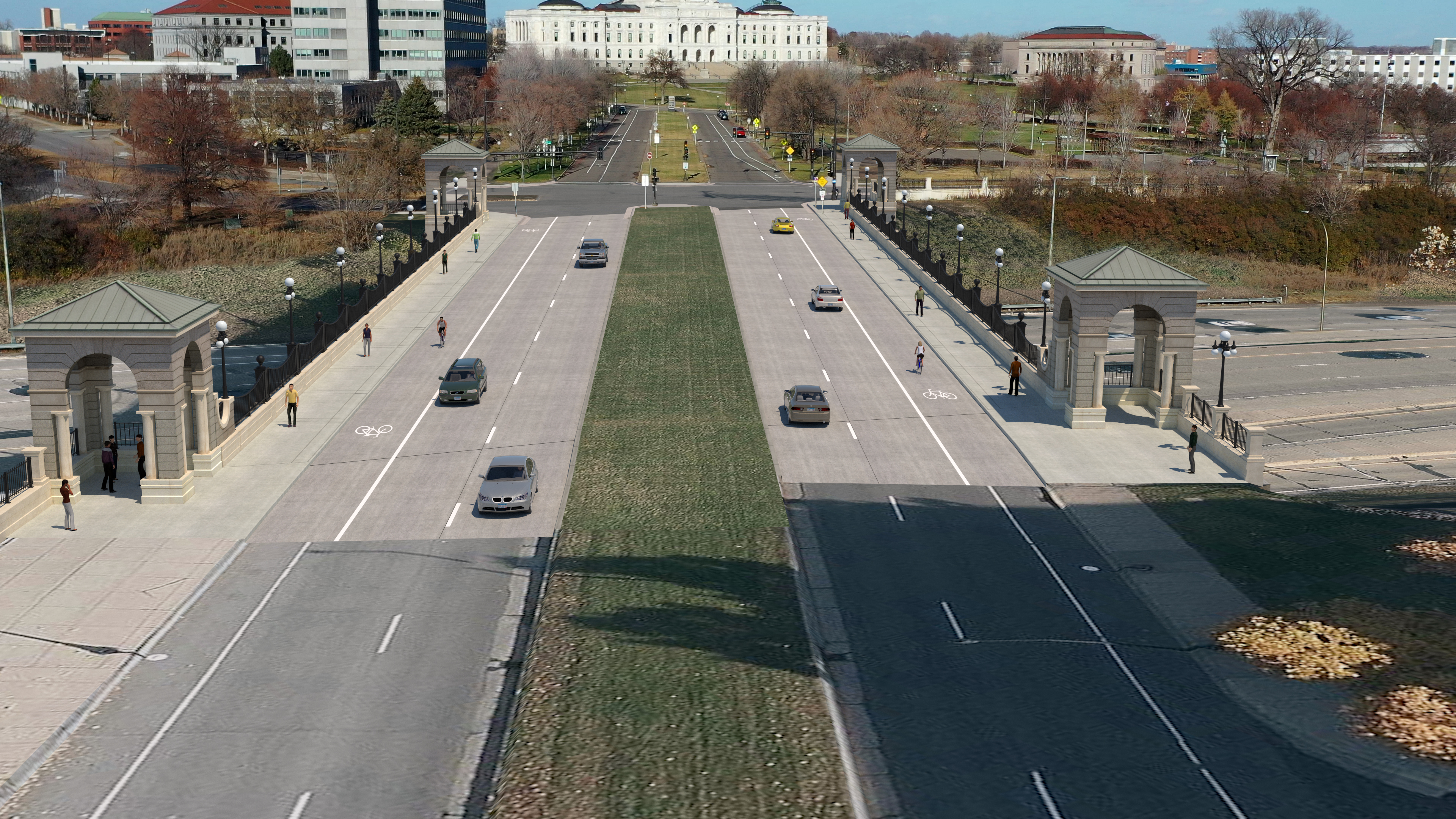
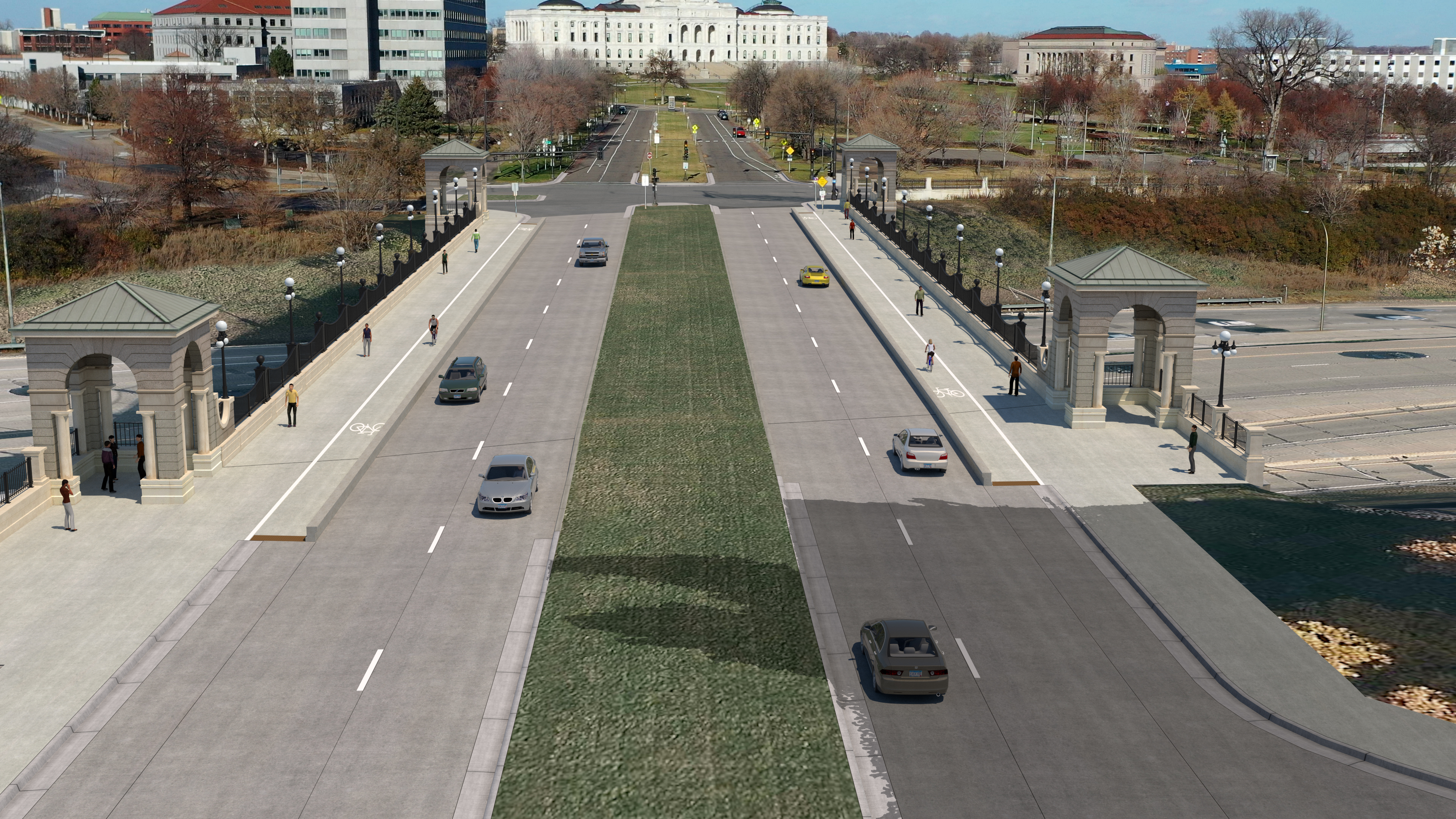
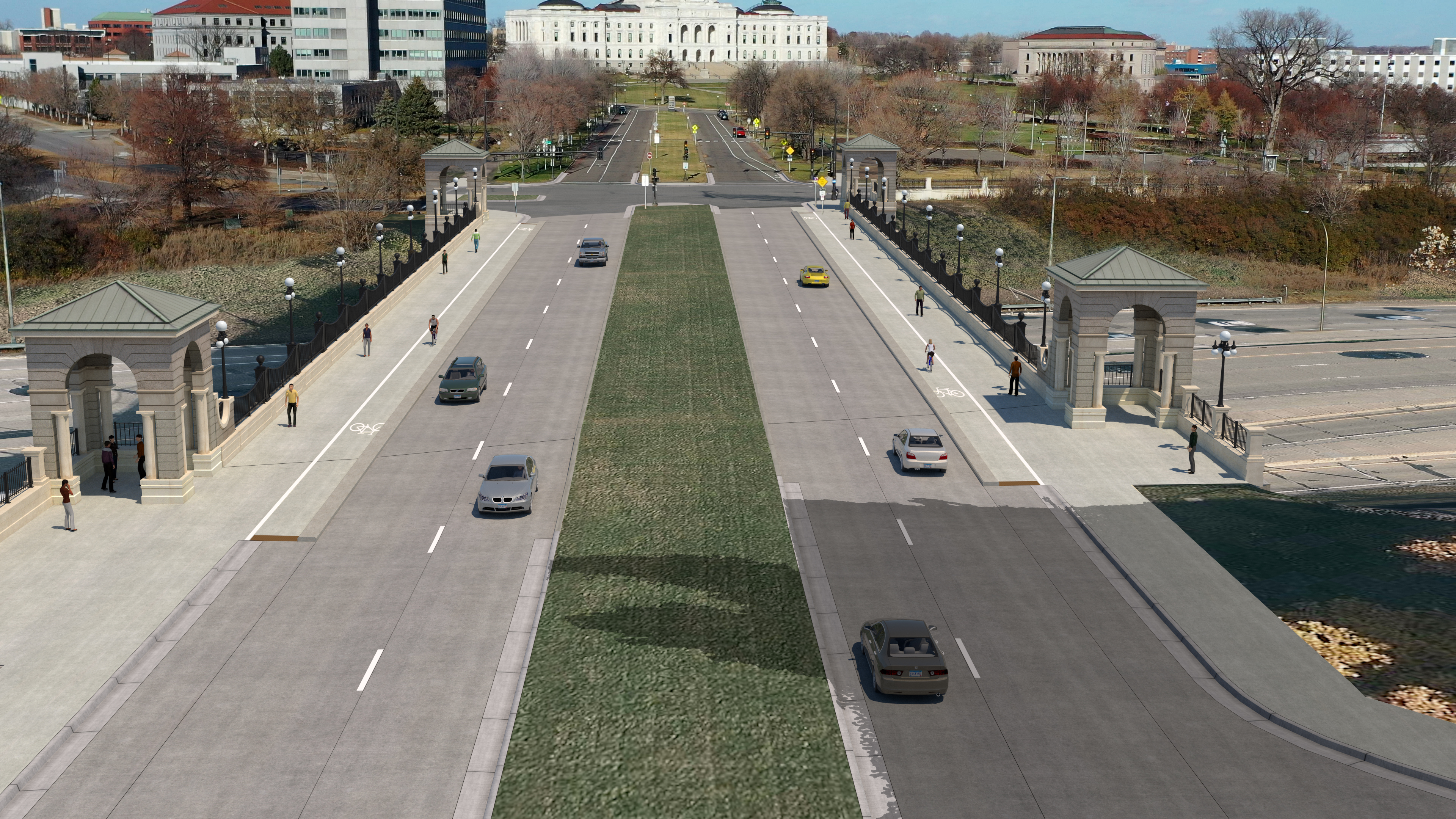
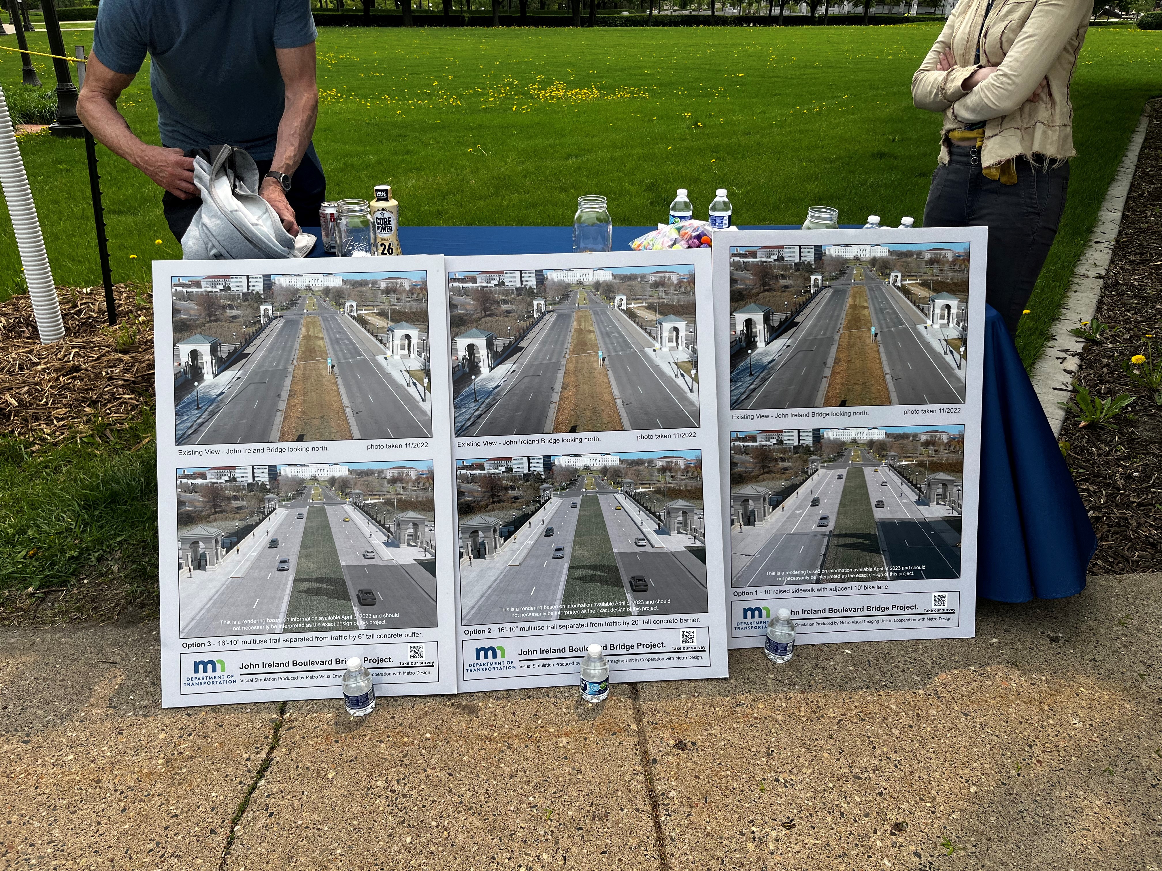
Layout options
We presented three roadway layout options to the public for consideration. The existing
bridge features:
Buffer separated combined 6 ft. bike and 10 ft.
sidewalk (not raised)
6 inch tall concrete buffer between vehicle lanes
and bike/ped lanes
Combined bike/sidewalk has directional marker
delineation (ground in pavement marking)
26 ft. planted grass median
Community engagement approach
To prepare for the upcoming careful disassembly and rebuild of the structure of the John Ireland Blvd. bridge
over I-94 in St. Paul, we began engaging community members on our plans for the bridge in March
2023, with the goal to create a dialogue between MnDOT and local stakeholders to ensure the project addresses
community concerns and that stakeholders understand what is happening every step of the way. Over the course of engagement:
663 people signed up for email updates on the project
301 people took the survey
165 people engaged with the us at pop-up meetings
23 people attended the hybrid project meeting
1,398 businesses and 2,751 residences received mailers with project information
24 stakeholder organizations were reached out to with project information and a toolkit for sharing details
with their audiences
Whether walking, biking, taking transit or driving, many people use this road and would like to see safety
improvements for pedestrians and cyclists. We sought feedback from the community on the three different
design options for the bike and pedestrian improvements on the bridge through direct outreach to organizations
and audiences in the project area, a hybrid public meeting, an online survey, sidewalk decals in the project area,
social media posts, two mailers, and pop-up meetings at local community events. To encourage broader awareness of the project, we also distributed a press release and reached out to local reporters. Coverage of the project appeared in the St. Paul Pioneer Press, Star Tribune, Finance & Commerce and KSTP-TV.
Website
We created a website for the John Ireland Blvd.
bridge project in March 2023. The
website was promoted on all project materials and outreach,
as well as sidewalk decals placed throughout the project area.
The website was designed to serve as a trusted resource
where all audiences could easily find project
details. It included a project overview and summary of work;
information on design and historical considerations and the
Section 106 review process; a link to the project survey; anticipated timelines and public engagement opportunities; and project team leads for people to contact with any questions.
The website also shared MnDOT’s Twitter and Facebook handles for people to follow to remain engaged, in addition to a project email sign-up link.
Stakeholder engagement
There are many affected stakeholders located in the John Ireland Blvd. bridge project area, including residents, bridge
users (commuters, visitors and bike users), nearby businesses, civic institutions, associations, nonprofits, advocacy groups,
and state and local government agencies.
We worked to engage directly with 24 stakeholder groups, sharing information about the project, the public
meeting and survey opportunities, as well as answering questions and listening to feedback. These groups included:
Stakeholder engagement
Stakeholder groups
Stakeholders
Civic institutions
St. Paul Cathedral
Minnesota History Center/Minnesota Historical Society
Saint Paul College
Regions Hospital
United Hospital
Public safety
St. Paul Police Department
St. Paul Fire Department
Capitol Security/Minnesota Department of
Public Safety
St. Paul Emergency Medical Services
Cycling and pedestrian advocacy groups
St. Paul Bicycle Coalition
Bicycle Alliance of Minnesota
Twin Cities in Motion
Local government
City of St. Paul
Capitol River Council
Summit University Planning Council
Ramsey County
Metropolitan Council
Metro Transit
State government
Department of Administration
Minnesota State Capitol
Business
St. Paul Area Chamber
St. Paul Downtown Alliance
Visit St. Paul
St. Paul Building Owners and
Managers Association
The team created and shared a toolkit of pre-drafted communications – including template social media and e-newsletter
content promoting the project, public meeting, and survey – with all stakeholder organizations. We encouraged them to
share information about the community engagement period. This direct outreach from stakeholders through their own
communications channels was the most effective way of reaching audiences, with a total of 213 respondents completing the
survey through these communications.
Finally, we also solicited feedback from government entities that are responsible for various aspects of the road
and project area, such as the City of St. Paul and the Capitol Area Architectural and Planning Board (CAAPB).
We developed a list of 663 stakeholders for email updates on the project through the website, pop-up meetings and survey.
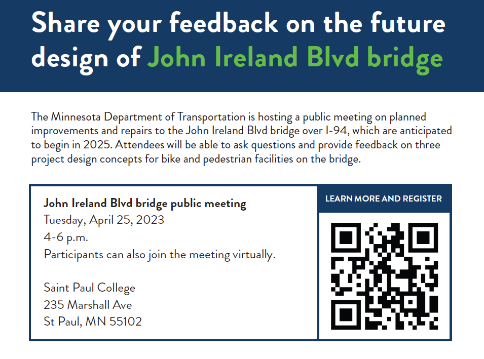
Hybrid public meeting
On April 25, 2023, we hosted a hybrid
public meeting about the planned improvements and repairs
to the John Ireland Blvd. bridge.
With the in-person component hosted at Saint Paul
College (paid parking was
compensated). The purpose of the hybrid meeting was to give
attendees an overview of the need for the project and the
anticipated timeline, as well as provide space for them to ask
questions and provide feedback on the three project design
concepts for bike and pedestrian facilities on the bridge.
We promoted the meeting multiple times over the course of six weeks across MnDOT’s Facebook,
Twitter and Instagram channels, with corresponding social media graphics and a Facebook event, through two
separate GovDelivery emails, multiple emails sent directly to audiences by project stakeholders, project website updates, and a physical mailer sent to residences and businesses in the project area. A total
of 23 people attended the hybrid meeting.
At the meeting, attendees had access to a project fact sheet, an informational Section 106 one-pager, a Section 106
consulting party application and a hard copy of the project survey (which was also available online). There were also
three boards displaying the design options for attendees to clearly see and understand each option being considered.
Attendees asked questions and/or provided feedback on the following topics:
Possibility of a two-lane road conversion
Snow removal
Road maintenance
Median landscaping
Daily bridge use by vehicles, bikes, pedestrians
Short barrier vs. tall barrier
Participating city and project stakeholders
Anticipated project timelines
Road safety
Importance of bridge access for public demonstrations/protest
Need for alternative routes during construction
A recording of the presentation given at the public meeting was posted as a video to the project website for people
who could not attend the meeting. We also sent a GovDelivery email recapping discussion topics and resources after the meeting and encouraging people to take the project survey if they had not done so already.
Pop-up meetings
Meeting people where they are is a vital component of building trust and modeling transparency during the public
engagement process.
For the John Ireland Blvd. bridge project, we reached out to staff of community spaces and events with the
request to host an outdoor pop-up for community engagement on the upcoming project. Our staff attended
the following five pop-up events, all of which were free, public events serving project area audiences.
May 12, 2023: Capitol complex food trucks (reached an estimated 50 people)
May 17, 2023: Capitol complex food trucks (reached an estimated 35 people)
June 2, 2023: 2023 Flint Hills Family Festival (reached an estimated 30 people)
June 21, 2023: Food Trucks Wednesdays in Rice Park (reached an estimated 38 people)
June 22, 2023: Frogtown Community Center Summer Kick-off (reached an estimated 12 people)
At each pop-up event, the three design option boards were displayed for table visitors to clearly see and understand
each option. We also made available printed project fact sheets, an informational Section 106 onepager,
a Section 106 consulting party application, a hard copy of the project survey and a hard copy of the project
presentation given at the April 25 hybrid meeting.
Except for the May 12 pop-up, each tabling also had an informal visual polling opportunity to gauge preference toward each of the three designs. Using three mason jars and colorful pom-poms, we asked table visitors to place a
pom-pom of their choice into the mason jar that corresponded with their favorite bridge design option. In addition
to being a more high-level way to naturally engage people, this activity was useful to get a quick (and colorful) visual
gauge of the most popular design option – which was option 2.
For the Flint Hills Family Festival pop-up, we brought the Minnesota GoMobile to engage parents and
children – a hybrid vehicle with an array of black and white
line drawings and graphics that provide a canvas for children and their families to color using washable chalk markers – in
addition to the regular printed materials and pom-pom poll.
The most common questions during all pop-up engagement
included inquiries around construction timeline, the size
difference between the barrier heights for design options 2 and
3, the possibility of a two-lane road option, concerns around
snow maintenance and turn lanes, and cost differences.
Survey
We developed an online survey to gather feedback from stakeholders and members of the public on
the many elements being considered in the three design options for the John Ireland Blvd. bridge project.
The 26-question survey was available April 17-June 30, 2023. It was divided into four sections:
User experience, design layout options, construction and demographics. A variety of multiple choice and open-ended
questions gave survey respondents the opportunity to both react to the three design options while also
sharing feedback of their own.
A total of 301 people took the survey. Most survey respondents identified as white (89%), have regular use
of a vehicle (94%) and primarily speak English at home (95%). The age range of respondents was mixed with
representation from 18-75+ year olds.
To ensure the survey reached as broad and relevant an audience as possible, we shared it across a
variety of mediums, including the project website, in multiple GovDelivery email and social media updates, at public
meetings and community pop-up events, and in toolkits for key stakeholders to share with their unique audiences.
Tracking how participants were accessing and taking the survey was important to better understand which
communication methods were most effective. To gain this insight, we created five unique links, each
associated to a specific medium leading to the survey: The project website, the GovDelivery email blasts, MnDOT
social media posts, stakeholder toolkit communications and the hybrid public meeting.
The stakeholder survey link was the most popular, with a total of 213 respondents
using the link to complete the survey. One reason we believe this link was used so frequently: A bicycle coalition
stakeholder group with a high social media following shared it to their Twitter account, where followers then used the
link to access the survey.
Key themes and takeaways
Throughout the engagement period, we asked individuals and organizations for their
feedback on the proposed layout options and sought insight from people in the project area to
plan for continued dialogue during construction.
The majority of respondents indicated a preference for Option 2: The barrier-separated bike
and pedestrian facility with the 20 inch-tall barrier. Full discussion of the preferred concept below.
There was robust discussion with participants about existing traffic counts and the potential for
narrowing the roadway from four lanes to two lanes, which we evaluated.
In the public meeting and survey, many people raised issues of concern within the project area
for us to consider as it makes future improvements.
Lane reduction
We received 77 comments in the
survey asking it to consider reducing the
number of lanes based on perceived and
actual traffic counts, as well as safety
concerns. This was also brought up
frequently during the hybrid public meeting
and community pop-up meetings.
Those in favor of a lane reduction cited low daily vehicle traffic, safety and speeding concerns due to the width of the
roadway and lack of traffic, needing more room for bikes and pedestrians, and the existing road condition on John
Ireland Blvd. beyond the bridge.
While we considered this feedback and evaluated two-lane options, this change was beyond the scope of the
structural bridge repair and replacement project and would significantly delay construction on the scheduled repair.
In consultation with the City of St. Paul, we agreed to complete the bridge repair project as originally scheduled
while working with the city and other stakeholders to consider a two-lane conversion in the future. All the layout
options for bike and pedestrian facilities offer future flexibility if a conversion is approved.
Common questions
Do traffic counts in the project area support a four-lane roadway?
Who is responsible for snow removal and road maintenance on the
bridge, including the bike and pedestrian lanes?
Can the median landscaping be changed?
Preferred concept
During in-person meeting opportunities and the online survey, we asked participants to share their layout
preference for the bridge. In the survey, of the respondents that shared a layout preference, 60% selected option 2.
They cited greater physical protection from cars for bikes and pedestrians and greater visibility of the higher barrier.
Some also liked that the bike and pedestrian lanes were at the same level, but others disliked this feature. This was
affirmed during informal polls and feedback during pop-up meetings.
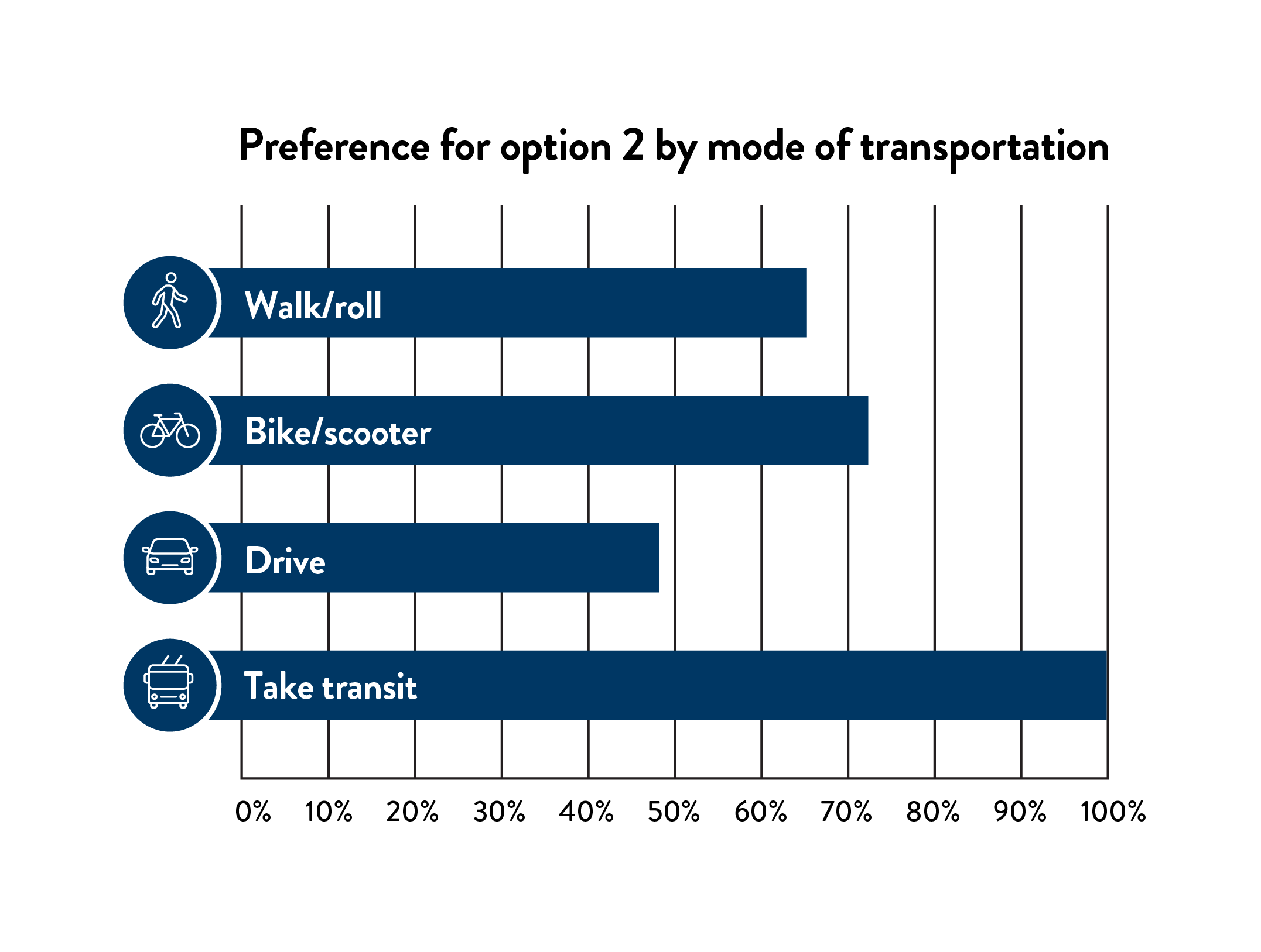
Those who indicated that they most often walked, took transit, biked or scootered on John Ireland Blvd. heavily favored
option 2. Drivers indicated a strong preference for option 2, followed by option 1. Drivers who indicated a preference
for option 1 shared that it was similar to the existing layout, it seemed less difficult to maintain in the winter, and
created fewer conflicts between bicyclists and pedestrians.
Other feedback
Safety: Throughout the survey and public meeting, people shared safety concerns for traveling across
the bridge and wanted greater separation between vehicles and other modes of transportation, longer
crossings, and reduced vehicle speeds. Respondents also shared a need to consider conflicts between bike
and pedestrian traffic in the shared trail.
Winter maintenance: Many people asked questions about winter maintenance of the bike and pedestrian
lanes and raised concerns about snow removal with barrier-separated facilities. In some cases, when
vehicle lanes are cleared, snow piles into the bike/pedestrian lanes or the lanes are not large enough for
snow removal equipment. There was confusion about who would be responsible for clearing the road, bike
and pedestrian lanes going forward.
Median landscaping: While the 26 ft. grass median will be maintained in all options, a few people offered
suggestions for additional landscaping, such as native grasses and plants or a pollinator-friendly garden.
People also wanted to ensure that vegetation disrupted during construction is restored.
Barrier height: Several people sharing a preference for Option 2 presumed the taller barrier was safer.
More information would help people compare the 20 inch barrier and 6 inch barrier. If pursued, people wanted
more information about how the 6” barrier would be visible to drivers, strategies for preventing cars from
going over the barrier and how the barrier would work at right-turn lanes.
Bridge significance: While most survey respondents did not indicate they use the bridge daily or weekly,
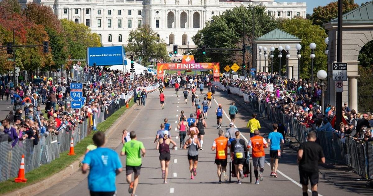
many pointed to the bridge’s significance to the community. People mentioned how the bridge is used
during the Twin Cities Marathon, as a march/protest path, and visiting the Minnesota State Capitol,
including large tour groups and regular activity during the legislative session.
Alternate routes for construction: People will be significantly impacted by the bridge closure. Several
respondents indicated a need to maintain safe walking and biking paths on alternate routes during
construction, in addition to vehicle detours. Noise, duration of closures, bus connections for Metro
Transit, and school bus access to the state Capitol and Minnesota History Center were also mentioned as
key concerns during construction.
Across engagement activities, most people preferred option 2, which
would create a 20 inch concrete barrier between vehicle traffic and the
bicycle/pedestrian path. After consultation with project stakeholders,
we selected option 2 as the preferred concept for construction.
This layout will be further refined to incorporate feedback.
Next steps
Following approval of the layout, we plan
to begin construction in 2026.