Sign up for project email updates
About this project
Update
Beginning May 5, 2025, crews will be planting a mix of 170 coniferous, deciduous and ornamental trees and sizes at locations along the boulevard and other MnDOT right of way through LeRoy. Planting work is scheduled to take about three days.
Once planting is completed, the final layer of paving will begin. Crews hope to finish this work by the end of the day on Friday, May 9, weather permitting.
Final striping is expected to be done the week of May 12. Crews will grind the stripes into the pavement and apply the adhesive crosswalk markings.
Motorists are asked to watch for crews at work, and if parking, choose a spot on a side street or in a driveway during the daytime hours to ensure that the planting and paving can advance without delays.
Summary of work
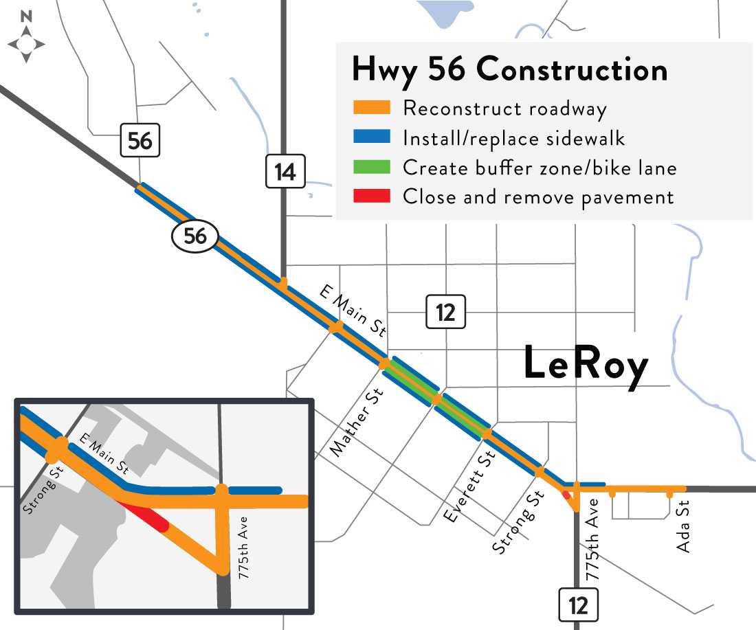
A 1.2-mile stretch of Hwy 56 was reconstructed in LeRoy to address deteriorating pavement conditions, improve drainage, enhance student crosswalk safety and make pedestrian improvements to meet current accessibility standards. At the same time, the City of LeRoy replaced aging city utilities underneath the road. Construction started April 29 and the majority of it was completed on Nov. 4, 2024.
The following improvements include:
- Reconfigured Mower Co. Rd. 12, Hwy 56 and Main St. E. intersection to improve safety by reducing vehicle speeds while maintaining efficient traffic flow
- Constructed a cul-de-sac west of Mower Co. Rd. 12
- Created a buffer zone between traffic and parking from Mather St. to Everett St. for biking
- Improved school crosswalk safety by constructing a bump out at Mower Co. Rd. 14 and creating a wider school parking zone
- Replaced aging storm water, sanitary sewer and water main utilities underneath Hwy 56
- Extended water main past Ada St.
- Replaced and installed new curb and gutter
- Replaced and installed new sidewalks
- Landscaping, such as adding trees to boulevards (likely in 2025)
Details can be viewed on the project layout map.
MnDOT plans to conduct additional landscaping work, which will include adding new trees to boulevards. The final paving layer will be completed in spring of 2025. Crews have marked the road with temporary striping and will provide the final striping after the final paving is done next year. This will allow the pavement to settle through the winter and spring prior to final topping of the road.