List of evaluated roadside properties
Craigie Flour Mill Historical Marker
SHPO number: OT-OTT-001
- 1998 inventory form (PDF)
- 2019 inventory form (PDF)
- National Register of Historic Places (NRHP) Nomination Form
- Photo Gallery
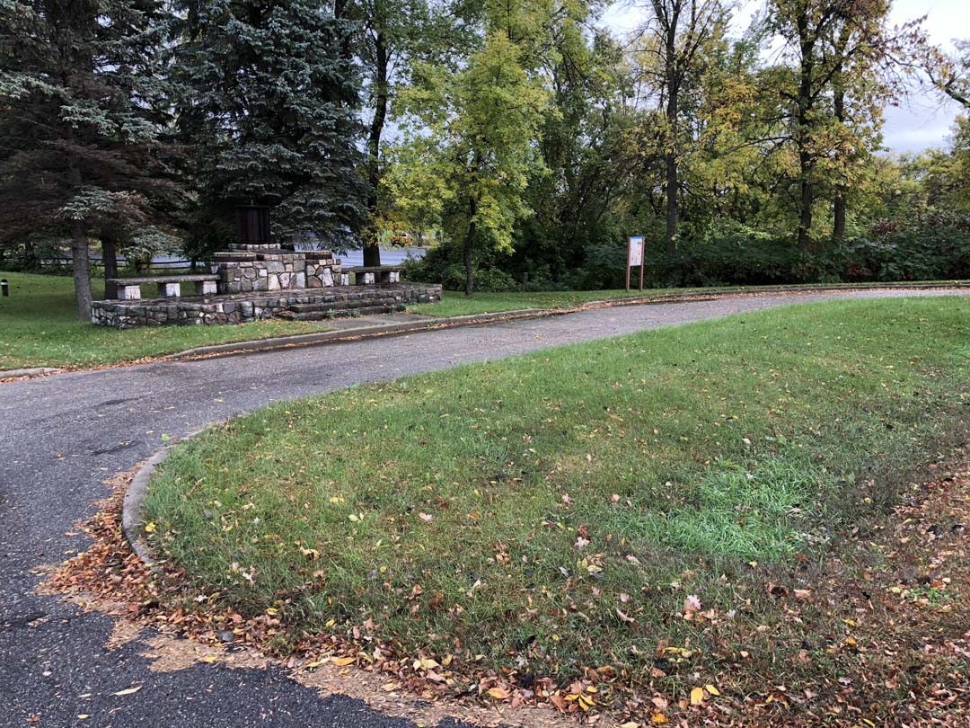
The Craigie Flour Mill Historical Marker is part of a small, 0.3-acre wayside along Trunk Highway 78 approximately one-half mile north of County Road 128 in Otter Tail County. The wayside is located along Balmoral Creek, which flows under TH 78 to Otter Tail Lake. The marker commemorates the Craigie Flour Mill, which was built in 1870 by Scottish immigrant James Craigie and demolished by the 1930s. The Craigie Flour Mill Historical Marker and the associated wayside was built in 1940 and listed on the National Register of Historic Places in 2002.
Significant historic elements and status
Evaluated under the Multiple Property Documentation Form entitled “Federal Relief Construction in Minnesota, 1933-1941,” the Craigie Flour Mill Historical Marker is significant for its association with the formative years of the Roadside Development Division of the Minnesota Department of Highways (now MnDOT). It is a good example of a small roadside park that was developed as part of the Roadside Development Division’s partnership with federal relief agencies to provide essential work and job training during the Great Depression. TH 78 became a state highway in 1934 and was paved in this location in 1937. The wayside and the marker replaced an earlier marker at this location when they were constructed in 1940 by the boys and young men employed by the National Youth Administration, which served young people between the ages of 16 and 25.
Although not listed on the National Register for its significance in design or landscape architecture, the Craigie Flour Mill Historical Marker is a good example of the National Park Service Rustic Style used in a small wayside with a shrine-type historic marker. The site and the marker were designed by A.R. Nichols, a consulting landscape architect for the Minnesota Highway Department. Although the wayside has a standard semicircular entrance drive, Nichols’ design preserved the site’s large deciduous trees and intended for the landscaping to blend the roadside park into its surroundings and minimize the scars left by road construction. The prominently placed marker is built of local pink and gray granite field rocks likely split on site and laid in a random pattern over a poured concrete core. In a unique use of historic objects or artifacts in marker design, the marker incorporates two mill stones and an iron water wheel salvaged from the ruins of Craigie Mill.
Features that contribute to and help convey the significance of the Craigie Flour Mill Historical Marker include: the marker with integrated benches, the spatial organization and circulation path, and the topography and vegetation. Although the wayside was originally equipped with portable log and timber picnic tables also likely built by the National Youth Administration, none remain today.
Accessible features on the site
- Accessible walk and interpretive signage planned for 2024 construction