How we support Complete Streets
Transportation hierarchy tool
The Complete Streets Project Transportation Hierarchy Tool offers a starting point. The tool provides a baseline project hierarchy based on context, user type, and transportation characteristics. The tool is primarily for MnDOT staff who plan, design, and engineer roadway projects. It can apply at project planning, scoping, design, construction, and operations/maintenance.
Key considerations
Jurisdiction
The tool can apply to all roadway jurisdictions.
Functional classification
The tool can apply to all functional classification types. Most MnDOT routes are principal arterials and minor arterials.
Safety and user priorities
Project transportation hierarchies should consider safety and user vulnerability as a primary factor. People walking and biking are more vulnerable to injury than those operating a motor vehicle. User priorities are not the same in all context categories
Freight, transit, and maintenance and operations
These user groups have unique considerations that should be included in the modal priority discussion.
Project types
The transportation hierarchy should apply to all categories of project types. Major reconstruction projects may provide a clear opportunity to reallocate space to address the needs of all users. Preservation projects provide opportunity to address inequities, particularly for the most vulnerable users.
Design guidance
The transportation hierarchy is a starting point for project design; it is not a design tool. Staff should refer to the latest design guidance documents and allow for design flexibility.
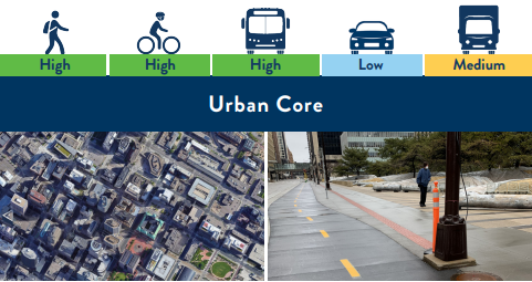
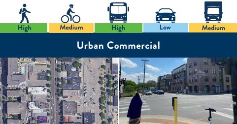
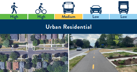
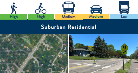
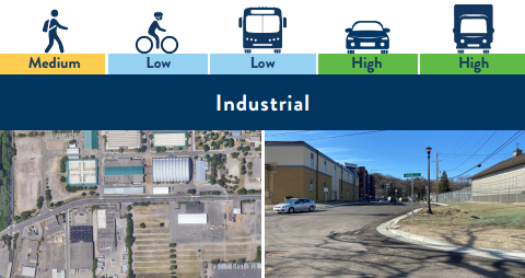
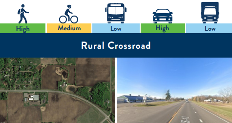
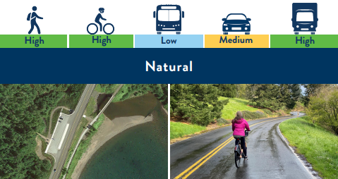
Context Categories and Baseline Transportation Hierarchy
The tool provides a baseline transportation hierarchy based on preventing injury for the most vulnerable user groups, expected volume based on context, and precedent. The tool assigns a baseline value for each user group per context category based on a high, medium, and low scale. A rating of ‘high’ means that user group is expected in the project area and merits a high level of consideration. These ratings are a starting point, not a project-specific solution. Project-specific transportation hierarchy ratings should be calibrated in collaboration with local partners. Full guidance on applying the Hierarchy Tool is available in the Complete Streets Handbook (PDF).
| Context category | Walking | Bicycling | Transit | Autos | Trucks |
|---|---|---|---|---|---|
| Urban Core | High | High | High | Low | Medium |
| Urban Commercial | High | Medium | High | Low | Medium |
| Urban Residential | High | High | Medium | Low | Low |
| Suburban Commercial | High | High | Medium | Low | Low |
| Suburban Residential | High | High | Medium | Medium | Low |
| Industrial | Medium | Low | Low | High | High |
| Rural Crossroad | High | Medium | Low | High | Low |
| Rural | Medium | Low | Low | High | High |
| Natural | High | High | Low | Medium | High |