Minnesota Department of Transportation

511 Travel Info

Highway 243 Osceola Bridge

Franconia Township MN and Osceola WI

About this project

Highway 243 Bridge over the Saint Croix National and Scenic Riverway between Highway 95 in Franconia Township and Highway 35 intersection in Osceola, Wisconsin project location map

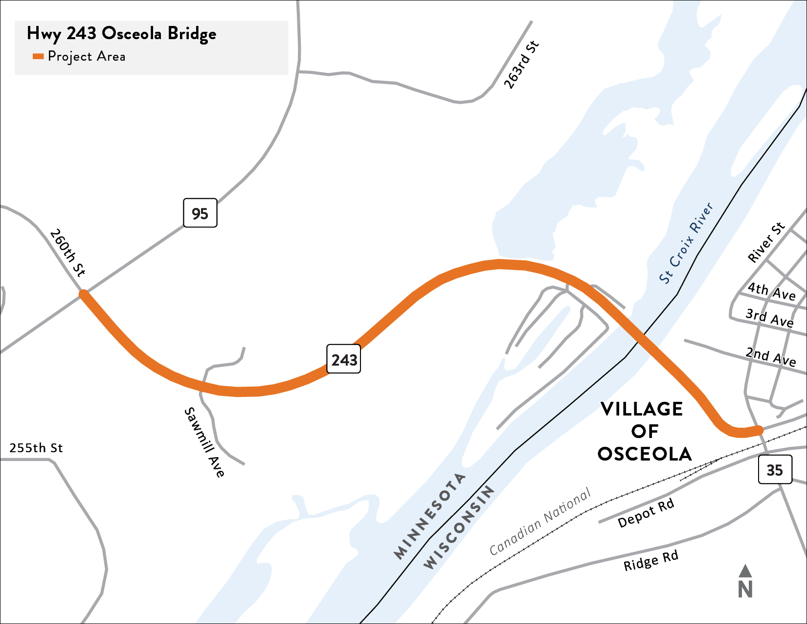
Hwy 243 project location map.
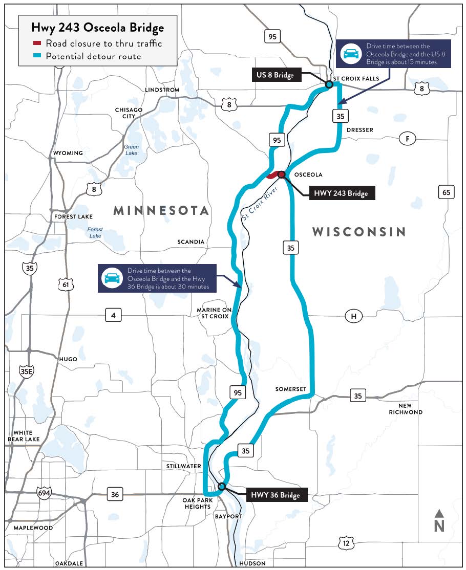
View full-size map

We are in process of designing the reconstruction of the Hwy 243/Osceola Bridge over the St. Croix National and Scenic Riverway, in partnership with the Wisconsin Department of Transportation (WisDOT). The Osceola Bridge was built in 1953.

The bridge is reaching the end of its service life due to its age. However, the current condition of the bridge is safe for general travel. MnDOT inspects the bridge annually and evaluates the bridge deck, trusses, supports and other overall factors to evaluate the condition of the bridge and identify needed repairs. The last inspection took place in April of 2022 and no new areas of concern were identified. Commercial trucks over certain weights are restricted from using the bridge.

The Hwy 243 bridge will be replaced. MnDOT and WisDOT completed an evaluation of the existing piers and footings (to request a copy of this document, contact us) and decided that it is not feasible to reuse any portion of the existing structure. Additional needs for the project include accommodations for people walking and biking, and drainage improvements. The project team will consider bridge alternatives that include bike and pedestrian accommodations. The sensitive environmental constraints on both the Minnesota and Wisconsin road approaches will also be taken into consideration as these changes are evaluated. Additional information can be found in the project’s Purpose and Need document.

After completing a multi-step evaluation process that looked at seven potential bridge alignments, the project team has identified a recommended alignment for the bridge. The recommendation is to maintain the existing alignment. This recommendation was presented to the public on Wed, May 10 at a public meeting in Osceola, WI. The public can learn more about the evaluation process, recommended alignment, and next steps here on the project website. In addition, the public can contact or submit comments to the project team on the contacts tab of this webpage. Check out the narrated Public Meeting presentation video!

Summary of work

The purpose of this project is to maintain a reliable highway connection over the St. Croix River for Hwy 243 between Washington/Chisago counties in Minnesota and the Village of Osceola and Polk County in Wisconsin. The project team will work with federal, state and local interests to minimizing project impacts to the St Croix River and other natural resources in the area.

Project needs

The “need” identifies the transportation problems to be addressed by the project outcomes.

  • Bridge conditions
  • Evaluate pedestrian bridge crossing by foot and by bicycle
  • Drainage conditions

Additional considerations

  • Bridge traffic during construction
  • River navigation and access during construction
  • Osceola Landing Access
  • Hwy 243 Wayside Rest (MN)
  • Hwy 243 Emergency Pull-off (WI)

Traffic and safety summary

This map illustrates detour routes that would likely be used for a future temporary bridge closure.

Detour routes that would likely be used for a future temporary bridge closure.
Click image for larger version

Traffic volume

The Average Annual Daily Traffic (AADT) along the bridge is approximately 5,600 vehicles* with a truck percentage of 7.5%. During summer months, traffic on the bridge may increase up to 23%. The morning peak occurs at 7 a.m. and the evening peak at 4 p.m.

*Year 2019 AADT from MnDOT’s online traffic data mapping platform. MnDOT and WisDOT have plans to collect new traffic data in 2022.

Crash history

Crashes were reviewed on the bridge as well as the intersection extents of Hwy 243. A total of eight crashes occurred on the bridge between 2015-2019. Thirteen intersection crashes were present at the Hwy 95 intersection while five intersection crashes were identified at the Hwy 35 intersection during the same time period.

Pedestrians/bicycles

The bridge does not currently have dedicated space for bicyclists or pedestrians however there are known local sources of bicyclists and pedestrians that may use the bridge. Facilities include full sidewalk and path systems serving restaurants, shopping, and parks immediately adjacent to the Hwy 243 bridge. There is also a path system in Gristmill Park, near Cascade Falls, that provides access to the river under the bridge. Areas of interest to pedestrians and bicyclists are in Minnesota across the river from Osceola. These areas include the National Park System boat landing, public wayside rest area, and wildlife property.

Potential alternate routes/detours

Two potential alternate routes have been identified for use during the closure of Hwy 243: Hwy 8 and Hwy 36. The travel time between Hwy 243 and US 8 is approximately 15 minutes on either side of the bridge while the travel time between Hwy 243 and Hwy 36 is approximately 30 minutes on either side of the bridge.

Traffic impacts

All traffic impacts are tentative and weather dependent.

Upcoming

Information about upcoming traffic impacts will be provided as details become available. Motorists may expect lane, road and bridge closures throughout construction. There will be a period in which the bridge will need to be closed. The duration of that closure is one of the many items that will be considered during the alternative evaluation.

The project team will evaluate river access and any construction impacts that might occur. The team recognizes that access to the river and the Osceola Landing are important to residents and visitors by both road and the river. Keeping access open as much as possible is important.