This webpage is not updated over the weekend/overnight. For up-to-date information on traffic impacts, visit 511mn.org.
Traffic impacts
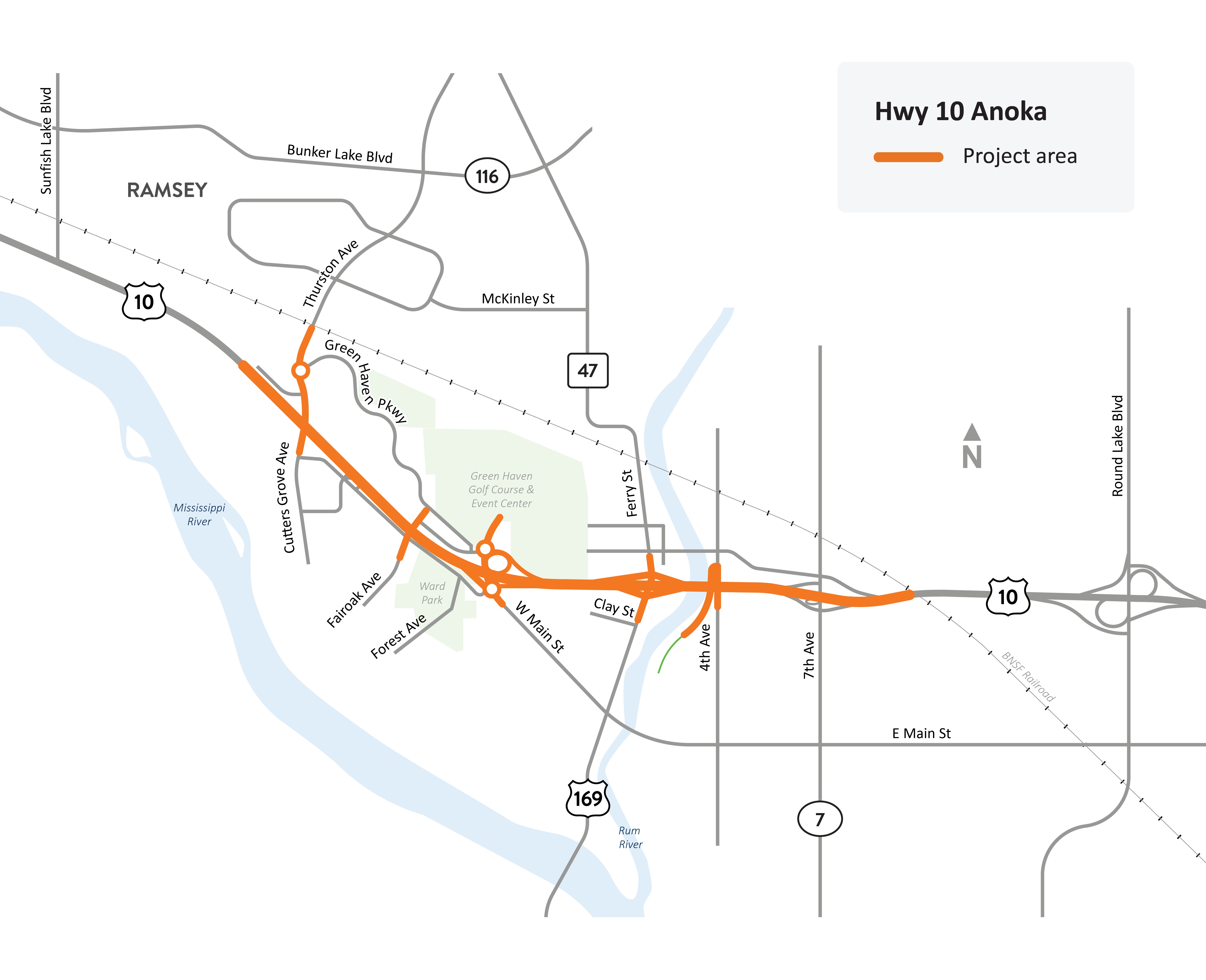
Hwy 10 in Anoka project location map
All traffic impacts are tentative and weather dependent.
Upcoming
Information about upcoming traffic impacts will be posted as details become available. Motorists can expect daytime lane closures on Hwy 10 in both directions through Anoka to complete final construction.
Traffic signal changes
The temporary traffic signal at McKinley St. and Hwy 47/St. Francis Blvd. will remain in place until the city of Anoka’s Hwy 47 project installs a permanent signal.
Traffic delays expected
Travel will be significantly delayed during construction:
- Plan your trip before you leave and give yourself plenty of extra time. Try and travel outside of rush hour times.
- Explore a route that isn’t affected by the road work. Look for a different highway route that doesn’t go through Anoka. Even a longer route may take less time when you consider construction impacts.
- For the safety of Anoka residents, follow the posted detours and avoid cutting through local neighborhoods.
- Your regular route may be affected. Check the project webpage frequently for updated ramp and road closures, and for the recommended detours.
- Use Metro Transit buses, Northstar commuter rail, carpooling, Park & Ride lots to travel in and out of Anoka. Train travel won’t be affected by road construction.
- Some Metro Transit bus stops are impacted by construction. Visit Metro Transit’s website for more information.
- Consider working from home.
- Cabin and vacation travelers who normally take Hwy 10 should consider using another route. Major work on I-94 is mostly complete between Maple Grove and Clearwater providing two to four lanes in each direction.
- Bookmark this site and visit frequently for current and upcoming traffic impacts, and sign up to receive email updates
- Visit 511mn.org or download the Minnesota 511 app on your Apple or Android device for real time traffic information
Several nearby roads received upgrades and improvements prior to construction. These investments will help accommodate increased traffic during Hwy 10 construction:
- Hwy 47/169 resurfacing
- 7th Ave. resurfacing
- Hwy 47 and Bunker Lake Blvd. intersection improvements
- Green Haven Pkwy. Phase II construction project
- Bunker Lake Blvd. improvements in Ramsey between Armstrong Blvd. and Sunfish Lake Blvd.
About this project
MnDOT and the City of Anoka are working together to reconstruct and improve roads and bridges on Hwy 10 between Thurston Ave. and 7th Ave. through Anoka. When complete, the two-year Hwy 10 Anoka project will improve traffic flow, decrease traffic delays and increase safety.
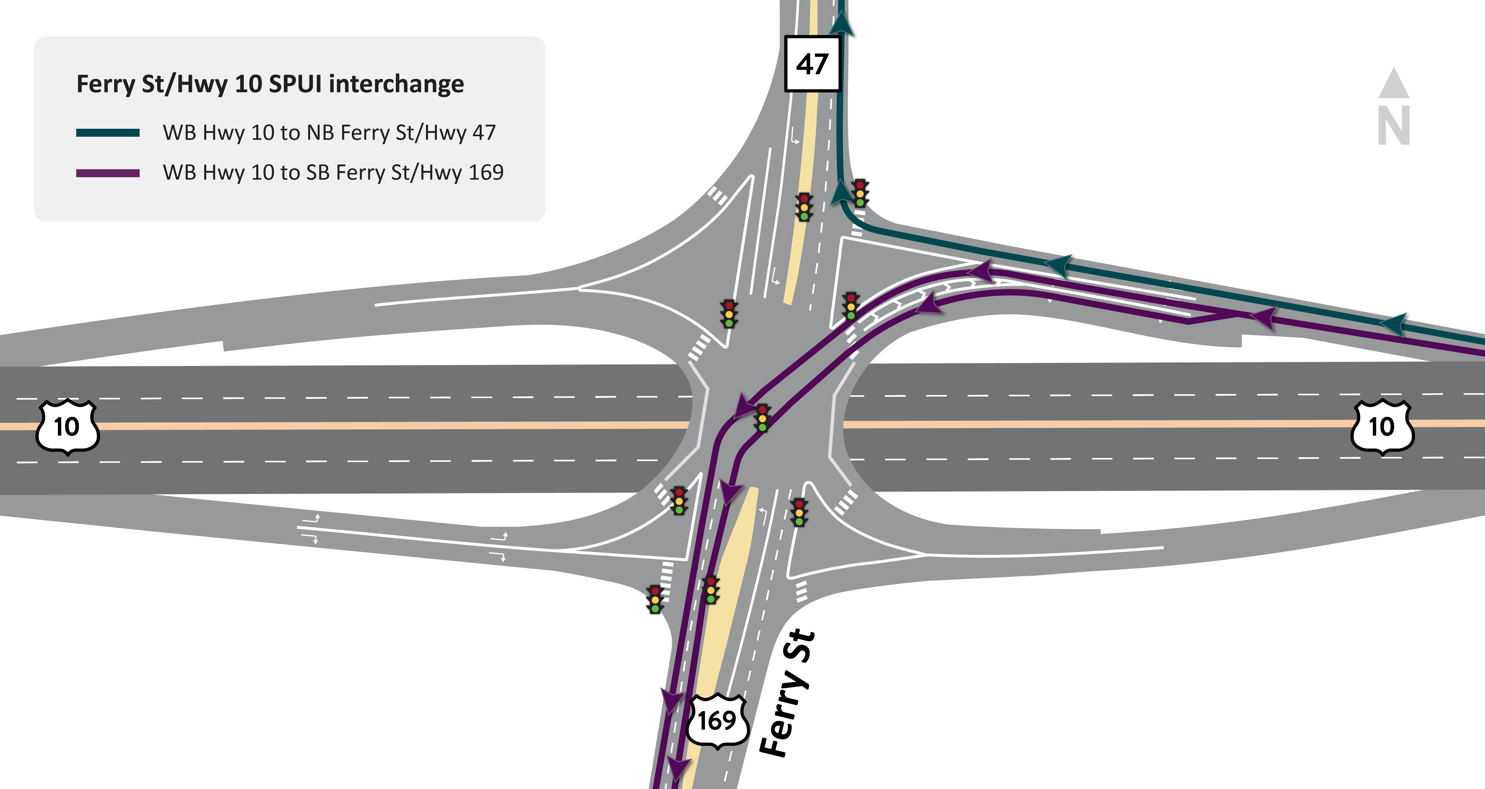
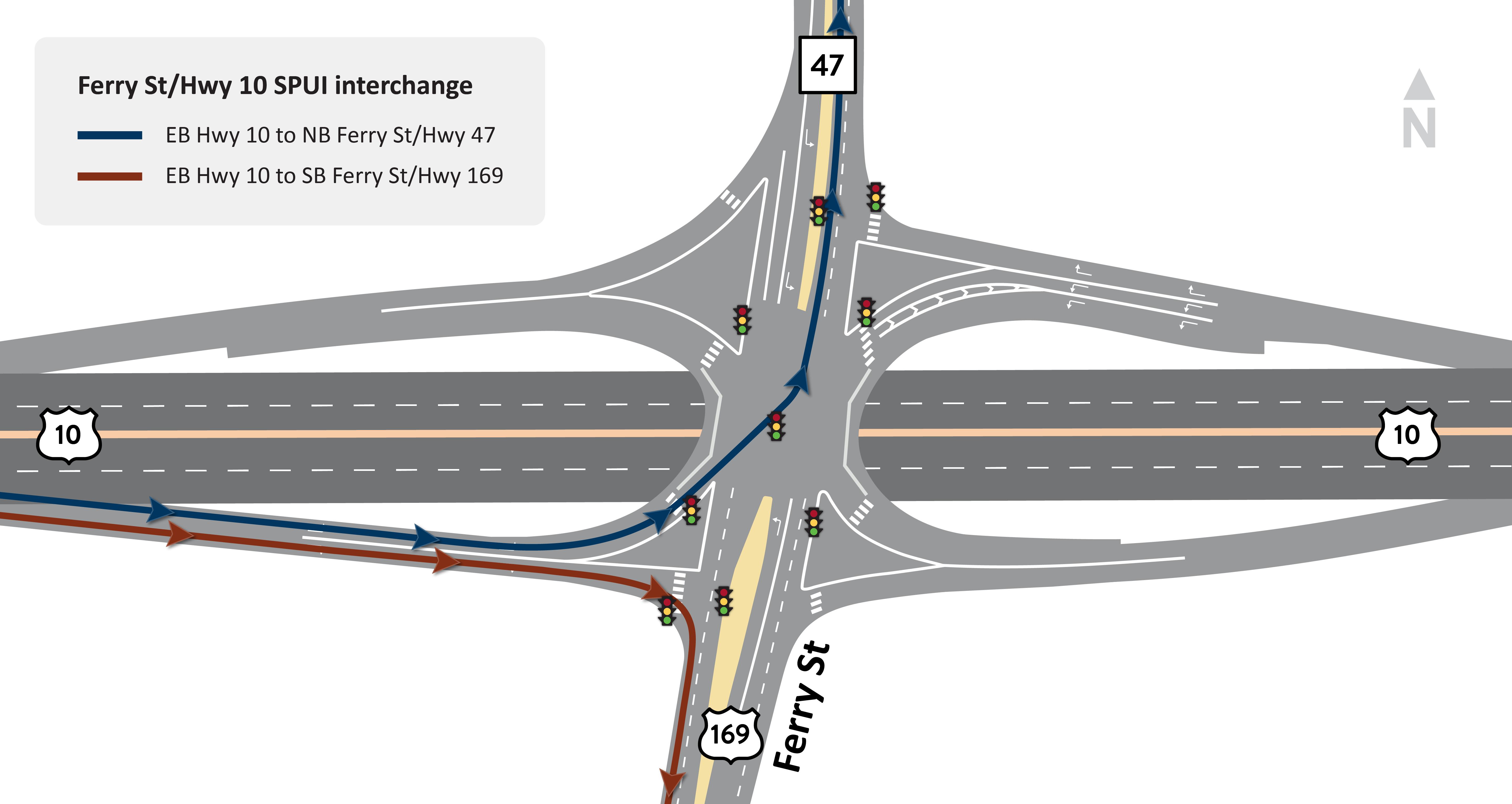
Single-point urban interchanges
The Ferry St. interchange has been reconstructed as a single-point urban interchange (SPUI). This design can safely and efficiently move high volumes of traffic in a limited area. Similar interchanges are located throughout the Twin Cities metro area, including Hwy 10 at Hanson Blvd. in Coon Rapids and Hwy 65 at Main St. (125th Ave.) in Blaine. Review the various traffic movements below that show how to navigate the Ferry St. SPUI:
- Ferry St. to WB Hwy 10 (PNG)
- Ferry St. to EB Hwy 10 (PNG)
- WB Hwy 10 to Ferry St. (PNG)
- EB Hwy 10 to Ferry St. (PNG)
Summary of work
- Thurston Ave. intersection: Hwy 10 will be elevated to go over Thurston Ave. An interchange with a roundabout will replace the signal intersection. Drivers will have on/off access.
- Fairoak Ave. intersection: An underpass will be constructed. Hwy 10 will be elevated above Fairoak Ave. Drivers will not have on/off access to Hwy 10 from Fairoak Ave.
- Main St. intersection: Roundabouts will be constructed on the north and south side of Hwy 10 at the end of the ramps. Drivers will have on/off access.
- West Main St. extension will be improved on the south side of Hwy 10, and will connect directly to Fairoak Ave.
- Green Haven Pkwy. intersection: A roundabout will be constructed on the north side of Hwy 10 at the intersection of Green Haven Pkwy. and Thurston Ave. Drivers will have on/off access from Thurston Ave.
- Verndale Ave. intersection: Access to Hwy 10 will permanently close and Verndale Ave. will become a cul-de-sac.
- Hwy 47/Ferry St. intersection: Hwy 10 access to Hwy 47/Ferry St. will change. The current diamond interchange will be replaced with a Single Point Urban interchange and improved for less congestion. Drivers will have on/off access.
- 7th Ave.: Minor bridge repair work. Drivers will have on/off access at temporary ramps.
- 4th Ave.: Overpass will be updated and replaced. The Rum River Regional trail will be realigned from its current location and combined with the 4th Ave. bridge.
- Rum River Bridge replacement: The bridge over the Rum River bridge will be rebuilt and replaced. Drivers can still use Hwy 10 to cross over the river during construction.
- Safety and connectivity for people who walk, bike and roll: Major improvements throughout project area including addition of multiple sidewalks & trails.
- For people who walk, bike and roll, the detour routes are long but unfortunately with the geographical challenges in the project area, it is difficult to find shorter routes. With every road closure, a safe detour for walking, biking and rolling is set up using the best route available
- Frontage roads: Improvements on both sides of Hwy 10 with options for local trips & access to interchanges at Thurston Ave. & Main St.
- Access lanes: New lanes to enter and exit Hwy 10 between Ferry St. and 7th Ave.
- Minor repairs to the Hwy 10 bridge over BNSF railroad
- Noise walls in multiple locations throughout Anoka